
Width 50 km (31 mi) E/W | Length 120 km (75 mi) N/S Area 6,000 km² Elevation 2,842 m | |
 | ||
The Stauning Alps (Danish: Stauning Alper) are a large system of mountain ranges in Scoresby Land, King Christian X Land, northeastern Greenland. Administratively the Stauning Alps are part of the Northeast Greenland National Park zone.
Contents
- Map of Stauning Alper Greenland
- History
- Geography
- Subranges and other features
- Mountains
- Glaciers
- Climate
- References
Map of Stauning Alper, Greenland
This mountainous area was named after Danish politician Thorvald Stauning (1873–1942) who had helped to finance expeditions to east Greenland planned and carried out by Danish explorers.
History
The Stauning Alps had been partly mapped earlier and named Rink Bjerge by Lauge Koch’s 1926–27 expeditions, being referred to as a "wild and jagged range of mountains." The range thus described obviously corresponded to the eastern end of the Stauning Alps and the adjacent Werner Range, but the name was not approved owing to the lack of detailed maps. Finally the range was thoroughly surveyed and mapped in 1932 by Koch during aerial surveys made during the 1931–34 Three-year Expedition to East Greenland.
There is almost full documentation of climbing in the Stauning Alps by the successive expeditions having visited the mountain system. Most of the available climbing reports have either been published or deposited in the archives of the Danish Polar Center (DPC), the Royal Geographical Society of London (RGS) or the British Mountaineering Council (BMC).
Dansketinden, the highest point of the Stauning Alps was first climbed by Swiss mountaineers John Haller (1927–1984), Wolfgang Diehl (1908–1990) and Fritz Schwarzenbach on 5 August 1954. The second ascent was made by a 1964 Italian expedition led by Guido Monzino (1928 – 1988).
Geography
The Stauning Alps are bound to the north by the King Oscar Fjord and its Segelsällskapets branch, to the east by the Skel Valley, the Schuchert Flod river and the Holger Danske Briller lakes, to the west by the Alpefjord —a branch of the Segelsällskapets— and the Borgbjerg Glacier, and to the south by a part of the Nordvestfjord, the NW branch of the Scoresby Sound.
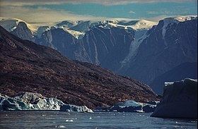
The range is very rugged with numerous high rocky peaks and active glaciers in almost all valleys. The mountains are made up of granite, harder in the northern than in the southern subranges. Therefore, The mountains in the north of the Stauning Alps are generally more craggy, while those in the south are more eroded and have a relatively smoother appearance.
The whole area of this vast range system is an uninhabited, desolate mountainous expanse. The nearest settlement is Ittoqqortoormiit and the nearest airfields are Nerlerit Inaat Airport at Constable Point to the east and Mestersvig to the north. Access to the range requires a special permit.
Subranges and other features
The Murchison Range (Murchison Bjerge) (72°18′N 25°0′W) is a subrange located in the northwestern area of the Stauning Alps that was named after Scottish geologist Roderick Impey Murchison (1792 – 1871). It stretches between the Sedgwick Glacier and the Alpefjord.
The Syltoppene (72°20′N 24°33′W) are a mountain ridge with needle-like summits at the northern end of the Stauning Alps that was named by A.G. Nathorst in 1899. Satan's Gallery (72°4′N 25°7′W) is a ridge with a series of formidable peaks NNE of Korsspids and south of the Gully Glacier that was named by the 1963 Cambridge University Expedition.
The Alliance Col is a 2,250 m high mountain pass named by the 1992 Scottish Stauning Alps Expedition.
Mountains
The Stauning Alps have a big concentration of mountains higher than 2,700 metres (8,860 ft). The highest point is Dansketinden (2,842 m). Other noteworthy peaks are:
Glaciers
Practically all the valleys in the Stauning Alps are filled by active glaciers that mostly flow towards the North, East or South. Generally those glaciers flowing towards the west are steep and have dangerous icefalls with deep crevasses.
Some of the glaciers in the range system are very large, such as the Spaerre Glacier (Spærregletscher) and Sefstrøm Glacier to the west, the Skjoldungebrae to the north and the Bersaerkerbrae (Bersærkerbræ) to the east. Other important glaciers in the Stauning Alps are:
Climate
The Stauning Alps lie in the high Arctic zone. Polar climate prevails in the area of the range, the average annual temperature in the area being -16 °C . The warmest month is July when the average temperature rises to -2 °C and the coldest is January with -21 °C.