
Number 18 States | ||
 | ||
Areas 22,140 km (8,549 sq mi) (Khartoum) – 348,770 km (134,659 sq mi) (Northern) | ||
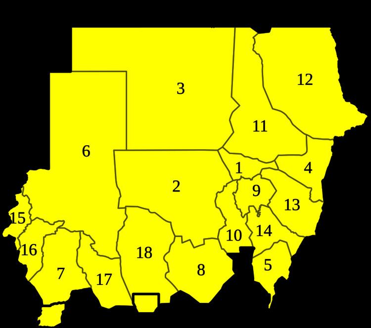
Below is a list of the 18 states of Sudan, organized by their original provinces during the period of Anglo-Egyptian Sudan. Arabic language versions are, as appropriate, in parentheses. States that were not provinces before 1994 are marked with (*). Transliterations from Arabic to English may vary; in particular, the article "al" is sometimes transliterated as "el". Numbers correspond to those of the map at right. Prior to 9 July 2011, the Republic of Sudan was composed of 25 states. The ten southern states now form part of the independent country of South Sudan. Two additional states were created in 2012 within the Darfur region, and one in 2013 in Kurdufan, bringing the total to 18.
Contents
States of the Republic of Sudan
The following 18 states form the territory of the Republic of Sudan.
History
Anglo-Egyptian Sudan had eight mudiriyat, or provinces, which were ambiguous when created but became well defined by the beginning of the World War II. The eight provinces were: Blue Nile, Darfur, Equatoria, Kassala, Khartoum, Kurdufan, Northern, and Upper Nile. In 1948, Bahr al Ghazal split from Equatoria.
There were numerous new provinces created on 1 July 1973. North and South Darfur were created from Darfur, while Kurdufan divided into North and South Kordofan. Al Jazirah and White Nile were split off from Blue Nile. River Nile split off from Northern. Red Sea was split off from Kassala.
A further fracturing of provinces occurred in 1976. Lakes split from Bahr al Ghazal, and Jonglei split off from Upper Nile. Equatoria divided into East and Western Equatoria. There were thus eighteen provinces. In 1991, the government reorganized the administrative regions into nine federal states, matching the nine provinces that had existed from 1948 to 1973. On 14 February 1994, the government reorganized yet again, creating twenty-six wilayat (states). The majority of the wilayat were either the old provinces or administrative subregions of a province. As part of the new government structure in South Sudan in 2005, Bahr al Jabal was renamed Central Equatoria. In 2006, West Kurdufan was split and merged with North Kurdufan and South Kordofan.
In January 2012, the new states of Central Darfur and East Darfur were created in the Darfur region, bringing the total number of states to 17. In July 2013, West Kurdufan was reestablished.
Former states now part of South Sudan
On 9 July 2011, the ten southern states became the independent country of South Sudan. They were further divided into 86 counties.