
Population 3,610 (2012 est.) Sovereign state United Kingdom Postcode district G76 Dialling code 0141 | Post town GLASGOW | |
 | ||
Lieutenancy areas East Renfrewshire, Renfrewshire | ||
Stamperland is a suburban residential area in East Renfrewshire, Scotland. Part of the Greater Glasgow conurbation, it is situated on the west bank of the White Cart Water about 4.5 miles (7.2 km) south of Glasgow city centre, and just outside the city boundary. The area's proximity to Glasgow effectively makes it a suburb of the city, though it remains administratively separate. Adjoining areas are Netherlee to the north, Giffnock to the west and Clarkston to the south. It is also bordered by Clarkston Road to the west and the White Cart Water to the east. It is served by the Glasgow Central to East Kilbride line through Clarkston railway station.
Contents
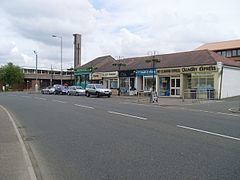
The area is mainly housing, but there is a small group of local shops located at the junction of Clarkston Road and Stamperland Gardens. Also at this location is Stamperland Parish Church (Church of Scotland). Other local facilities include a social club, bowling and tennis clubs and a gun club.
Also nearby is the large Overlee Park and a small barbers at the top of the train station exit ramp.
Stamperland has its own pipe band "Stamperland Pipe Band" who are currently the RSPBA Champion of Champions for Grade 3A, and the European Champions.
Stamperland medley sanquhar 2014
Demography
For census purposes, Stamperland is classified as a separate locality within the settlement of Greater Glasgow. The most recent estimate, from mid-2012, gives a population of 3,610.