
Time zone CET/CEST (UTC+1/+2) Area 113.4 km² Population 7,687 (31 Dec 2008) | Elevation 1 m (3 ft) Postal codes 26935, 26936, 26937 Local time Saturday 2:11 PM Dialling code 04732 | |
 | ||
Weather 11°C, Wind NW at 21 km/h, 55% Humidity | ||
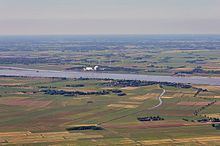
Stadland is a municipality in the district of Wesermarsch, in Lower Saxony, Germany. It is situated on the left bank of the Weser, approx. 32 km northeast of Oldenburg, and 42 km northwest of Bremen. On the west side Stadland bordered to the Jade Bight. Its seat is in the village Rodenkirchen, which is also part of this municipality as the villages Schwei, Seefeld and Kleinensiel. There are also many little Bauernschaften (hamlets) in Stadland.
Contents
Map of Stadland, Germany
In 1974 Stadland was built in cause of the Niedersächsische Gemeindereform. The former municipalities Rodenkirchen, Schwei and Seefeld and also Kleinensiel, a part of the former municipality Esenshamm (now: Nordenham) were built up to the new municipality Stadland.
Division of the municipality
Partnership
Stadland has a Partnership with the District du Petit Caux (Normandy, France). This partnership is affirmed by mutual attendance of grades and private people in each year.