
Country United States County Neosho FIPS code 20-62500 Elevation 272 m Population 620 (2013) | Time zone Central (CST) (UTC-6) GNIS feature ID 0475120 Area 3.16 km² Local time Saturday 12:01 AM | |
 | ||
Weather 12°C, Wind N at 18 km/h, 89% Humidity | ||
St. Paul is a city in Neosho County, Kansas, United States. As of the 2010 census, the city population was 629.
Contents
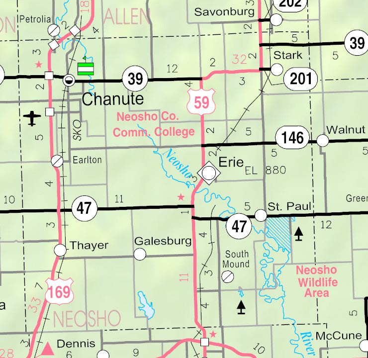
- Map of St Paul KS 66771 USA
- Osage elders visit st paul kansas
- History
- Geography
- 2010 census
- 2000 census
- Education
- Notable people
- References
Map of St Paul, KS 66771, USA
Osage elders visit st paul kansas
History
Father John Schoemakers, S.J. founded Osage Mission on April 28, 1847. Called the "Apostle to the Osage" and the "Father of civilization in Southeast Kansas," he served for 36 years as spiritual director, doctor, steward, lawyer, judge, catechist and preacher to the Osage. He served as an officially appointed U.S. postmaster of Osage Mission from 1851 to 1864. With the relocation of the Osage he ministered to the needs of the newly arrived settlers. He built the present St. Francis Church stone structure. Father Schoemakers is buried in St. Francis Cemetery one quarter mile east of the Church.
The other leading man in the Osage Mission was Kentucky-born John Allan Mathews. He was married to Mary Williams and after her death to her sister Sarah Williams. The Williams sisters were the daughters of William S. Williams and his Osage wife, A-Ci'n-Ga. They first met Mathews while attending school in Kentucky after their mother died. Mathews was a slaveholder and souther-sympathizer. He married Mary in Jackson County, Missouri in 1835 and was appointed blacksmith for the Senaca in 1837 and for the Osage in 1839. In about 1861 he gathered a group of Osage who tried to force Shoemakers to flee the area because they disagreed with Shoemakers abolitionist ideas. Matthews was killed by the 6th Kansas Cavalry under Gen. James G. Blunt in fighting at Chetopa, Kansas on Sep. 18, 1861.
During the Civil War both Union and Confederate troops took an interest in Osage Mission. From about December 1862 to June 1865 Union soldiers intermittently were stationed at or near the Mission. At least a couple times Confederate supporters entered Osage Mission or were in the immediate vicinity. For more see Osage Mission's post.
As early as 1883 there was agitation to change the name of Osage Mission because it suggested it was still an Indian Mission. Neona was suggested to honor the daughter of Chief Little Bear, but local protests favored the name of St. Paul. The reigning judge decided to allow the citizens to vote on the new name and St. Paul was chosen in an election held on April 11, 1895. Some claim the new name was selected to honor the Apostle Paul, but it was most probably selected in honor of St. Paul of the Cross, founder of the Passionists, who had just then established a home in Osage Mission. The name of the post office was officially changed from Osage Mission to Saint Paul in May 1895.
The historic St. Francis Hieronymo Church dedicated in 1884 has undergone its latest renovation in 2007 due to a storm on June 30, 2005 that knocked off the steeple. The Osage Mission-Neosho County Museum is directly south of the church. The Lone Elm School, a one-room school house that operated from 1867 through 1951 stands on the museum grounds.
A visit to the St. Francis Parish Cemetery reflects much of the history of the Osage Mission, as does the only remaining structure of the girls' school established by Mother Bridget Hayden when she arrived at the Mission in 1847. The Osage Mission Infirmary & Guest House is listed on the National Register of Historic Places and is managed under the name, St. Ann's Bed and Breakfast. The owners strive to maintain its history and authentic design.
St. Paul's homecoming is called Mission Days. It is held annually on Memorial Day Weekend with activities that begin on Thursday and conclude on Monday, including: races, music shows, dances, pony & draft horse pulls, parade, horseshoe tournament, carnival, kids games, golf tournament, calf penning & Calcutta, and Memorial Day services at the local cemeteries.
Geography
St. Paul is located at 37°31′7″N 95°10′25″W (37.518595, -95.173638). According to the United States Census Bureau, the city has a total area of 1.22 square miles (3.16 km2), all of it land.
2010 census
As of the census of 2010, there were 629 people, 240 households, and 153 families residing in the city. The population density was 515.6 inhabitants per square mile (199.1/km2). There were 259 housing units at an average density of 212.3 per square mile (82.0/km2). The racial makeup of the city was 98.1% White, 0.3% Native American, 0.3% Asian, 0.2% from other races, and 1.1% from two or more races. Hispanic or Latino of any race were 1.3% of the population.
There were 240 households of which 30.4% had children under the age of 18 living with them, 51.3% were married couples living together, 8.8% had a female householder with no husband present, 3.8% had a male householder with no wife present, and 36.3% were non-families. 32.9% of all households were made up of individuals and 16.6% had someone living alone who was 65 years of age or older. The average household size was 2.44 and the average family size was 3.12.
The median age in the city was 41.5 years. 24.5% of residents were under the age of 18; 6.3% were between the ages of 18 and 24; 21.8% were from 25 to 44; 23.3% were from 45 to 64; and 24.2% were 65 years of age or older. The gender makeup of the city was 49.4% male and 50.6% female.
2000 census
As of the census of 2000, there were 646 people, 226 households, and 148 families residing in the city. The population density was 576.7 people per square mile (222.7/km²). There were 241 housing units at an average density of 215.2 per square mile (83.1/km²). The racial makeup of the city was 97.21% White, 0.15% African American, 0.62% Native American, 0.62% Asian, 0.93% from other races, and 0.46% from two or more races. Hispanic or Latino of any race were 2.32% of the population.
There were 226 households out of which 33.6% had children under the age of 18 living with them, 54.4% were married couples living together, 7.5% had a female householder with no husband present, and 34.1% were non-families. 29.2% of all households were made up of individuals and 19.0% had someone living alone who was 65 years of age or older. The average household size was 2.63 and the average family size was 3.28.
In the city, the population was spread out with 26.6% under the age of 18, 7.9% from 18 to 24, 24.9% from 25 to 44, 17.8% from 45 to 64, and 22.8% who were 65 years of age or older. The median age was 39 years. For every 100 females there were 84.6 males. For every 100 females age 18 and over, there were 89.6 males.
The median income for a household in the city was $33,393, and the median income for a family was $41,563. Males had a median income of $30,385 versus $19,926 for females. The per capita income for the city was $16,012. About 6.1% of families and 10.7% of the population were below the poverty line, including 9.2% of those under age 18 and 15.4% of those age 65 or over.
Education
St. Paul is served by three Chetopa-St. Paul Unified School District Number 505 (USD 505) schools:
Three USD 505 attendance centers are also located in Chetopa, Kansas