The St. Joseph River is an 86.1-mile-long (138.6 km) tributary of the Maumee River in northwestern Ohio, and northeastern Indiana in the United States, with headwater tributaries rising in southern Michigan. It drains a primarily rural farming region in the watershed of Lake Erie. It shares its name with the St. Joseph River of Lake Michigan, but the two rivers flow in generally opposite directions.
At the end of the Wisconsin glaciation, the glacier's Erie Lobe retreated toward the northeast, leaving large debris deposits called moraines. The St. Joseph formed as a meltwater channel between the north limbs of two of these moraines, the Wabash Moraine on the west and the Fort Wayne Moraine on the east. At that time it joined the St. Marys River to drain into the Wabash River. Later, the shrinkage of Glacial Lake Maumee, the ancestor of modern Lake Erie, brought about the opening of the modern Maumee River, which captured the flow of the St. Joseph and the St. Marys, causing the St. Marys to reverse its course to meet the flow of the St. Joseph almost head-on.
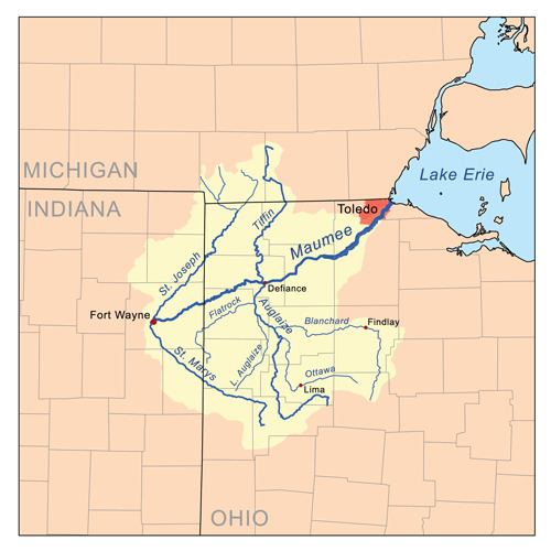
The St. Joseph River forms in northern Williams County, Ohio, at the confluence of the East and West branches at 41°38′54″N 84°33′55″W Both branches rise in southern Hillsdale County, Michigan. The headwaters of the East Branch are within 3 miles (4.8 km) of those of the St. Joseph River of Lake Michigan. Both branches initially flow southeast, then turn to the southwest to flow across the northwestern corner of Ohio past Montpelier. The St. Joseph enters De Kalb County in northeastern Indiana, flowing southwest past Saint Joe and into the city of Fort Wayne, where it meets the St. Marys River to form the Maumee River at 41°04′58″N 85°07′56″W.
From the mouth:
(left) Becketts Run
(right) Tiernan Ditch
(left) Ely Run
(left) Cedar Creek
Cedarville Reservoir(left) Nettlehorst Ditch
(left) Warner Ditch
(right) Wittmer Ditch(right) Haifley Ditch
(left) Swartz-Carnahan DitchDunton Lake
(right) Boger Ditch
(left) Metcalf Ditch
(right) Walker Ditch
(left) Dilley Ditch
(left) Wade Ditch
(left) Bear Creek(right) North Branch Hursey Ditch(right) Carper Ditch
(left) South Branch Hursey Ditch(right) Swander Ditch
(right) Nancy Davis Ditch
(left) Sol Shank Ditch(right) Weicht Ditch
(left) Sebert Ditch
(right) Varner Ditch
(left) Hoodelmier Ditch
(right) Melissa Ditch
(left) Buck Creek(left) Smith Ditch
(right) Mason Ditch(left) Metcalf Ditch(right) Harwood Ditch
(left) Christoffel Ditch
(right) Willow Run
(right) Amaden Ditch
(right) Greens Ditch
(right) Foulks Ditch
(left) Peter Grube Ditch
(left) Big Run(right) Ayford Ditch(left) Walters Ditch
(right) Streeter Ditch
(right) Praul Ditch(right) Mary Metcalf Ditch
(left) Teutsch Ditch
(left) Donnell Ditch(right) King Ditch
(right) John Smith Ditch(left) Haverstolk Ditch
(left) Russell Run
(left) Fish Creek(right) Cornell Ditch
(left) Hiram Sweet Ditch(right) Baker Ditch
(left) Hamilton LakeBlack Creek(left) Haughey Ditch
(left) Lillian Metz Ditch(right) Burch Ditch
Ball Lake
(left) Myers Ditch
Perfect Lake
(left) West Branch Fish Creek(left) Donald Nunkle Ditch
(left) Bluff Run
(left) Bear Creek(left) Tamarack Ditch
(left) Eagle Creek(right) North Branch Eagle Creek
(left) Nettle CreekNettle Lake(right) Mill Stream Drain
(right) East Branch St. Joseph River (rises in southwest Adams Township, Hillsdale County, Michigan at 41°54′17″N 84°33′52″W)
(left) Clear Fork
(left) Silver CreekMerry Lake
(left) Laird Creek(right) Nile Ditch
(left) Ransom Ditch
(left) Bird CreekBird Lake
(left) Newton Drain
(left) Dillon Drain
(left) Anderson Drain
(left) Goose Creek
(left) Lake Number OneLake Number Two
Pittsford Millpond(right) Otto Drain
Deer LakeTwin Lake
(left) West Branch St. Joseph River (rises just south of the intersection of Carpenter Rd. and W. Territorial Rd. in southern Cambria Township, Hillsdale County, Michigan at 41°38′53″N 84°41′24″W)
Lake Seneca(left) outflow from Lake La Su An
(right) East Fork West Branch St. Joseph River (rises in northwest Cambria Township, Hillsdale County, Michigan at 41°51′53″N 84°40′34″W)
(left) Jonas Brown Drain
(left) Carruthers Drain
(right) outflow from Cub Lake
Cambria Millpond(left) Cambria Drain
(left) Meade Drain
Bear Lake(left) Pike LakeBroom Lake
Lake WilsonBankers Lake
(left) West Fork West Branch St. Joseph River (rises from the outlfow of Rebeck Lake in northwest Camden Township, Hillsdale County, Michigan at 41°48′22″N 84°48′22″W)
(left) Joe Drain
(left) Prouty Drain
Rebeck LakeMead LakeTurner Lake
The St. Joseph River and tributaries drain all or portions of the following:
Allen County, Indiana
Cedar Creek Township
Cedarville
Eel River Township
Fort Wayne
Grabill
Milan Township
Perry Township
St. Joseph Township
Springfield Township
Washington Township
DeKalb County, Indiana
Auburn
Butler Township
Butler
Concord Township
Franklin Township
Garrett
Jackson Township
Keyser Township
Newville Township
Richland Township
Grant Township
Fairfield Township
Saint Joe
Smithfield Township
Spencer Township
Spencerville
Stafford Township
Troy Township
Union Township
Waterloo
Wilmington Township
Noble County, Indiana
Avilla
Allen Township
Green Township
LaOtto
Swan Township
Wayne Township
Steuben County, Indiana
Clear Lake Township
Hamilton
Otsego Township
Richland Township
York Township
Defiance County, Ohio
Milford Township
Williams County, Ohio
Bridgewater Township
Blakeslee
Center Township
Edgerton
Edon
Florence Township
Madison Township
Montpelier
Northwest Township
Pioneer
St. Joseph Township
Superior Township
Hillsdale County, Michigan
Adams Township
Amboy Township
Cambria Township
Camden Township
Camden
Jefferson Township
Osseo
Pittsford Township
Ransom Township
Reading Township
Wheatland Township
Woodbridge Township
Wright Township