
Country Canada Settled 1783 Time zone AST (UTC-4) Area 16.13 km² Area code 506 | Incorporated October 17, 1904 Postal code(s) E5C Population 1,543 (2011) Local time Friday 2:44 PM | |
 | ||
Weather 8°C, Wind N at 11 km/h, 36% Humidity | ||
St. George is a Canadian town in Charlotte County, New Brunswick.
Contents
- Map of Saint George NB Canada
- St george new brunswick walk about
- Geography
- History
- Government
- Transportation
- References
Map of Saint George, NB, Canada
St george new brunswick walk about
Geography
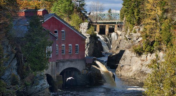
St. George is nicknamed the "Granite Town" and is located on the Magaguadavic River between Passamaquoddy Bay and Lake Utopia. It is 70 km west of Saint John. The Magaguadavic River flows through the town and into a large gorge and the St. George Dam at St. George, with cliffs on either side, there are also 5 or 6 caves.
History
The town was founded by Peter Clinch, a United Empire Loyalist who emigrated from the United States in 1784. Several granite quarries operated in the nineteenth and early twentieth century.
Government
The municipal government consist of a Mayor and five Councillors. After the 2012 municipal election, Danny Henry replaced the incumbent Sharon Tucker. Tucker was mayor since 2007. However Henry resigned during the summer of 2013 and Sharon Tucker regained her title as a result of uncontested by-election in October 2013. As of May 2016, Tucker was replaced as mayor by Crystal Cook, who was voted in during a municipal election and who remains the mayor as of today.
The Town of St. George is within the Provincial electoral district of Fundy-The Isles-Saint John West and the Federal riding of New Brunswick Southwest.
Transportation
The town is centered mainly between Route 1 to the North, Route 172 to the south-east along the most southern portion of Route 770.