
Main source Lake Panuke Length 34 km | Basin size 1,368 km (528 sq mi) Basin area 1,368 km² | |
 | ||
River mouth Confluence with the Avon Riversea level Progression | ||
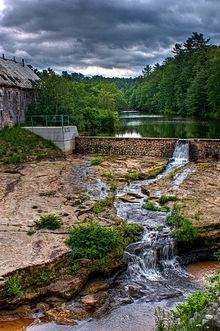
The St. Croix River is a river in Nova Scotia entirely contained in Hants and Halifax Counties. Its headwaters are Panuke Lake. The river has been exploited for water power. There were water mills in the nineteenth century and in the 1930s three hydroelectric dams were built; they still operate.
Contents
Map of St Croix River, Windsor, NS, Canada
The lower reaches of the St. Croix are tidal. There is a wide flood plain where the river has cut through limestone bedrock now exposed as white cliffs. The calcareous soil harbours the rare Rams Head Lady Slipper.
The Nova Scotia Government estimates that the number of people living within the St. Croix watershed numbered 19,233 in 2011.
History
The river and Panuke Lake were used as an important portage route first by the Mi'kmaq and later by European explorers and settlers. There is an unpopulated Indian reserve (St Croix Indian Reserve) on the lake.
European settlement began with the Acadians (who named the river, calling the region Pisiguit).
The Battle at St Croix (1750)
The Battle at St. Croix happened between New England Rangers and the Mi'kmaq. To capture the Acadians involved in the British defeat at the Fort Logis, Grand Pre the previous year, Cornwallis sent John Gorham (military officer) to Piziquid to construct Fort Edward (Nova Scotia) and imprison the Acadians. After two days of marching from Fort Sackville (present day Bedford), they come to the St Croix River. At the river a battle broke out with the Mi'kmaq. Gorham took over a saw mill and two local Acadian homes for protection. The Mi'kmaq numbers continued to grow, therefore Gorham sent a messenger to Fort Sackville for reinforcements, which ended the battle. After the Expulsion of the Acadians, New England Planters settled the area. Extensive land grants were let by the Nova Scotia colonial government beginning in 1761.
Today, the St. Croix is a popular river for canoe and kayaking enthusiasts. The lower floodplains are dyked and farmed. The river's tidal bore may be viewed at Tidal View Farm.