
Country United States ZIP codes 54024 Zip code 54024 Local time Friday 10:52 AM | State Wisconsin Time zone Central (CST) (UTC-6) Area code(s) 715 & 534 Population 2,094 (2013) | |
 | ||
Weather 5°C, Wind NE at 13 km/h, 66% Humidity Area 12.38 km² (12.1 km² Land / 28 ha Water) | ||
Pine ridge apartments in st croix falls wisconsin
St. Croix Falls is a city in Polk County, Wisconsin, United States. The population was 2,133 at the 2010 census. The city is located within the Town of St. Croix Falls.
Contents
- Pine ridge apartments in st croix falls wisconsin
- Map of St Croix Falls WI 54024 USA
- Geography
- 2016 census
- 2000 census
- Points of interest
- Notable people
- Education
- References
Map of St Croix Falls, WI 54024, USA
U.S. Route 8, Wisconsin Highway 35, and Wisconsin Highway 87 are three of the main arterial routes in the city.
Geography
St. Croix Falls is located at 45°24′43″N 92°38′20″W (45.411956, -92.638916).
According to the United States Census Bureau, the city has a total area of 4.78 square miles (12.38 km2), of which, 4.67 square miles (12.10 km2) is land and 0.11 square miles (0.28 km2) is water.
St. Croix Falls is adjacent to Taylors Falls, Minnesota, across The St. Croix River.
2016 census
As of the census of 2016, there were 2,693 people, 967 households, and 522 families residing in the city. The population density was 456.7 inhabitants per square mile (176.3/km2). There were 1,088 housing units at an average density of 233.0 per square mile (90.0/km2). The racial makeup of the city was 96.7% White, 0.3% African American, 0.5% Native American, 0.6% Asian, 0.4% from other races, and 1.5% from two or more races. Hispanic or Latino of any race were 1.8% of the population.
There were 967 households of which 26.0% had children under the age of 18 living with them, 39.1% were married couples living together, 11.2% had a female householder with no husband present, 3.7% had a male householder with no wife present, and 46.0% were non-families. 40.2% of all households were made up of individuals and 18.8% had someone living alone who was 65 years of age or older. The average household size was 2.14 and the average family size was 2.87.
The median age in the city was 44.3 years. 22.1% of residents were under the age of 18; 7% were between the ages of 18 and 24; 22% were from 25 to 44; 27.1% were from 45 to 64; and 21.8% were 65 years of age or older. The gender makeup of the city was 44.9% male and 55.1% female.
2000 census
As of the census of 2000, there were 2,033 people, 872 households, and 504 families residing in the city. The population density was 607.1 people per square mile (234.3/km²). There were 926 housing units at an average density of 276.5 per square mile (106.7/km²). The racial makeup of the city was 98.43% White, 0.05% Black or African American, 0.30% Native American, 0.20% Asian, 0.54% from other races, and 0.49% from two or more races. 1.33% of the population were Hispanic or Latino of any race.
There were 872 households out of which 30.0% had children under the age of 18 living with them, 47.2% were married couples living together, 8.1% had a female householder with no husband present, and 42.1% were non-families. 36.8% of all households were made up of individuals and 19.0% had someone living alone who was 65 years of age or older. The average household size was 2.22 and the average family size was 2.96.
In the city, the population was spread out with 24.0% under the age of 18, 6.9% from 18 to 24, 26.1% from 25 to 44, 22.2% from 45 to 64, and 20.8% who were 65 years of age or older. The median age was 41 years. For every 100 females there were 88.4 males. For every 100 females age 18 and over, there were 84.1 males.
The median income for a household in the city was $39,350, and the median income for a family was $54,063. Males had a median income of $40,185 versus $25,341 for females. The per capita income for the city was $21,384. About 2.9% of families and 5.8% of the population were below the poverty line, including 4.4% of those under age 18 and 10.9% of those age 65 or over.
Points of interest
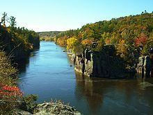
St. Croix Falls abuts two parks whose focal points are the St. Croix River (Wisconsin-Minnesota). It is home to the Park Headquarters for the St. Croix National Scenic Riverway, and it lies adjacent to the Interstate Park, a state park of Minnesota and Wisconsin that spans the Minnesota-Wisconsin state line along the St. Croix River Dalles with parts of the park on both sides.
St. Croix Falls is the western terminus of the Ice Age Trail and the Gandy Dancer Trail.
The St. Croix Falls Dam is located in St. Croix Falls.
The Cushing Land Agency Building, Lamar Community Center and Thomas Henry Thompson House are located in St. Croix Falls.
St. Croix Dock is located in St. Croix Falls. People can rent kayaks and canoes to enjoy the St. Croix River.
Notable people
Education
St. Croix Falls School District and Unity School District are the two local school districts. St. Croix Falls High School is the local high school.