
County Perry ZIP code 47576 Elevation 221 m | State Indiana GNIS feature ID 451415 Local time Friday 10:55 AM | |
 | ||
Weather 10°C, Wind W at 18 km/h, 91% Humidity | ||
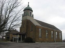
St. Croix is an unincorporated community in northern Oil Township, Perry County, Indiana, United States. It lies along on the western edge of the Hoosier National Forest, near the intersection of State Road 62, Interstate 64, and State Road 37, northeast of the city of Tell City, the county seat of Perry County. Its elevation is 725 feet (221 m), and it is located at 38°13′26″N 86°35′11″W (38.2239489, -86.5863736). Main points of interest in St. Croix include Holy Cross Church, cemetery, and Church Hall as well as the Etienne Saw Mill and Bear Hollow Mulch. Although St. Croix is unincorporated, it had a post office, with the ZIP code of 47576.
Contents
Map of St Croix, IN 47576, USA
History
A colony of Catholics settled at St. Croix in 1849. The community's namesake St. Croix (Holy Cross) church was founded in 1855. A post office was established in St. Croix in 1880, but has since closed.