
Postcode(s) 5373 Postal code 5373 | St Johns Koonunga Federal division Division of Wakefield | |
 | ||
St Johns is a locality southeast of Kapunda in the northern Barossa Valley, South Australia. Originally a private subdivision of the hundred of Belvidere, the boundaries of the locality were formalised in 2000 and the name formally adopted based on long-established use.
Contents
Map of St Johns SA 5373, Australia
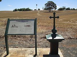
The foundation stone for the St John the Evangelist church was laid on 2 April 1850, however the building was not completed until 30 April 1854. A school was opened in 1859, run by the Sisters of St Joseph after 1868. From 1897, the school became a reformatory for girls until it closed in 1909.
Belvidere
Belvidere (34°21′14″S 138°56′55″E) is a historic locality in the bounded locality of St Johns. Belvidere had its own district council for over 65 years, which merged into the District Council of Kapunda on 23 May 1932. The District Council of Kapunda subsequently merged with others to form Light Regional Council. The original proposal to create the District Council of Belvidere in 1865 was to represent the interests of residents of the Hundred of Belvidere better than they believed could be done by a District Council of Light at the time.