
Population 1,498 (2011 census) Local time Friday 1:52 PM | Postcode(s) 7216 Postal code 7216 | |
 | ||
Location 18 km (11 mi) from Scamander36 km (22 mi) from St Marys89 km (55 mi) from Scottsdale148 km (92 mi) from Launceston Weather 17°C, Wind N at 18 km/h, 63% Humidity Points of interest Humbug Point Nature R, St Helens History Room, Bay of Fires | ||
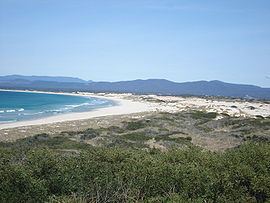
St Helens is the largest town on the north-east coast of Tasmania, Australia, on Georges Bay. It is known as the game fishing capital of Tasmania and is also renowned for its oysters (as are some other areas of Tasmania). It is located on the Tasman Highway, about 160 km east of Tasmania's second largest city, Launceston. In the early 2000s, the town was one of the fastest growing areas of Tasmania, and reached a population of 2049 at the 2006 census. St Helens is part of the Break O'Day Council, a council that includes the nearby town of Binalong Bay. A number of shops can be found in the town along Cecilia Street, such as a Supa IGA and Gallery Parnella.
Contents
Map of St Helens TAS 7216, Australia
History
St Helens was first used as a whaling base in the early 19th century. When tin was discovered in the surrounding area in the 1870s, St Helens became the shipping port for the mines. This was the first time a coach service had been introduced to the town; previous access had only been by sea. The town was named after St Helens, Isle of Wight. Today the town is a popular resort for fishing, swimming and other aquatic activities. Its economy is based largely on tourism, fishing and timber.
Georges Bay Post Office opened on 1 April 1869 and was renamed St Helen's in 1882.
The first European to explore the St Helens area was Captain Tobias Furneaux who sailed up the coast in 1773. He named the southern point of Georges Bay, St Helens Point.
By the 1830s Georges Bay was being used by whalers and sealers. Not surprisingly the settlement which grew up on the shore became known as Georges Bay and the local Aborigines became known as the Georges Bay tribe.
The first official land grant was provided in 1830 and in 1835 the small village was renamed St Helens. It would have continued to be an inconsequential port had not tin been discovered at Blue Tier in 1874. Suddenly the port, and the routes to the tin mines, were awash with miners. Over 1000 Chinese moved through the port. From 1874 until the turn of the century the tin mines prospered.
When the mines closed the miners moved to the coast and many of them settled in St Helens. Slowly the port changed so that today it has a major fishing fleet which is supported by boat building, ships chandlery and other ancillary activities. In recent times tourism, driven by fishing and the town's mild climate, has become important.
Notable residents of St. Helens include Lee Hartney from The Smith Street Band & Tom Busby from Luca Brasi.
Important Bird Area
The town is adjacent to the St Helens Important Bird Area, identified as such by BirdLife International because of its importance as a breeding site for seabirds and waders.
Waterfalls
35 km to the west is Mount Victoria Forest Reserve near the 90-metre (295 ft) high St Columba Falls.
Climate
St Helens has a mild temperate climate, with four distinct seasons. Summers are warm and sunny and winters are cool to mild. Rain falls consistently through the year, peaking slightly in winter. Being on the East Coast, St Helens winter temperatures are warmer than most parts of Tasmania. Summer temperatures are not as warm as inland areas, however are still warmer than Hobarts. St Helens record high temperature is 41.8 °C (107 °F), the equal second highest temperature recorded in Tasmania.