
Trail difficulty Easy Water None Length 9,600 m | Hazards Cars Tram(s) Route 112 | |
 | ||
Location Melbourne, Victoria, Australia Train(s) Stations along the South Morang line | ||
The St Georges Road Trail is a shared use path for cyclists and pedestrians, which follows Cheddar and St Georges Road in the inner northern suburbs of Reservoir, Preston and Thornbury in Melbourne, Victoria, Australia.
Contents
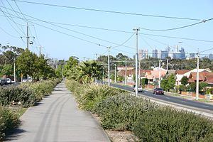
The trail is somewhat unusual, in that part of the way, it is located on the wide traffic island that divides the road in two, instead of being located beside the road. As a consequence, somewhat more care has to be taken when crossing at the intersections.
The trail was first constructed in the mid 1990s down the median strip of St Georges Road, but the section between Bell Street and Miller Street, which runs beside the road instead, was not completed until 2005.
Following the path
Leave the Western Ring Road Trail at Dalton Road. There are no signs to the St Georges Road Trail at this point. Dalton Road is unsuitable for cycling due to the heavy vehicles using the road. Using the footpath on the west side of Dalton Road, continue 400m south from the highway, to the start of a 600m low quality sandy shared path in the City of Whittlesea. It ends 160 metres north of the Keon Pde/Dalton Rd/Tunaley Pde intersection. Continue on the west side of Dalton Rd via the footpath to the intersection. Use the pedestrian crossing to cross to the east side of Dalton Rd and Tunaley Pde. The high quality trail in the City of Darebin, starts at Tunaley Pde, 1.4 km from the Metropolitan Ring Road and heads down the Yan Yean pipe reserve.
From there it follows Cheddar Road to a large intersection at the Reservoir shopping area and comes to a stop. Use the pedestrian crossings to cross SW to Reservoir railway station. The path restarts adjacent to the station car park. Continue between the reservoirs hiding behind the rows of trees lining the street on either side. The path continues diagonally in the GE Robinson reserve, beside the palms.
On the south side of the park the trail runs parallel to Robinson Road past Regent railway station. Follow the train line. 600m later, the path crosses the tracks and soon reaches St Georges Road and Murray Road.
Carefully cross over to the dividing strip going down the middle of St Georges Road. The path passes the Preston Campus of Melbourne Polytechnic. The trail stays on the dividing strip the whole way, except for a 500m section, between Ray Braham Gardens and Miller Street by the tram corral.
The most southerly end of the trail previously terminated at a roundabout with St Georges Road, Charles Street and Merri Parade. The roundabout was a blackspot for cyclists. The roundabout was removed in 2009. The Merri Creek Trail and Capital City Trail can be accessed by proceeding to the nearby Merri Parade.
Connections
North end at 37.696450°S 145.022673°E / -37.696450; 145.022673. South end at 37.776796°S 144.989642°E / -37.776796; 144.989642.