
Address St Croix 00820, USVI Phone +1 340-718-3367 | Area 155.4 km² Established January 9, 2003 | |
 | ||
Governing body Department of Planning and Natural Resources Hours Closed now Thursday8AM–5PMFriday8AM–5PMSaturdayClosedSundayClosedMonday8AM–5PMTuesday8AM–5PMWednesday8AM–5PMSuggest an edit Similar Salt River Bay National, Buck Island Reef National, Green Cay National Wildlife R, Point Udall, St George Village Botanical | ||
The St. Croix East End Marine Park (STXEEMP) was established to “protect territorially significant marine resources, and promote sustainability of marine ecosystems, including coral reefs, sea grass beds, wildlife habitats and other resources, and to conserve and preserve significant natural areas for the use and benefit of future generations.” It is the U.S. Virgin Islands’ first territorially designated and managed marine protected area (MPA).
Contents
The designation of STXEEMP unified and extended the previously identified territorially designated Areas of Particular Concern (APCs) at Great Pond Bay, East End, Chenay Bay, and the northern St. Croix Coral Reef System. STXEEMP encompasses nearshore habitats which are likely to interact with Buck Island Reef National Monument, and Lang Bank, a significant offshore fishing ground on the eastern edge of St. Croix’s subsea platform shelf. STXEEMP includes one of the most extensive, contiguous coral reef systems on the Puerto Rican/Virgin Islands shelf. The St Croix East End Marine Park encompasses an area of approximately 60 square miles (155 sq. km) along a shoreline of approximately 17 miles (27 km), from Green Cay on the north shore to Great Pond Bay on the south. The landward boundary of STXEEMP is the high-tide line; the STXEEMP is divided into management zones (see Rules and Regulations, below) that regulate activities. STXEEMP is entirely within territorial waters, and extends seaward to the 3 nautical mile limit for the Territory.
History and Mission
The St. Croix East End Marine Park was established by ACT NO. 6572 Bill NO. 24-0308 which passed the Virgin Islands’ legislature on December 23, 2002, and was adopted January 9, 2003. STXEEMP is St. Croix’s first and only territorially-designated and managed marine protected area. The mission of the STXEEMP is to promote the responsible use and management of significant coastal and marine resources through research and monitoring, education, restoration, and community engagement to protect, and preserve the ecological and cultural value for residents and visitors.
Habitats and Species
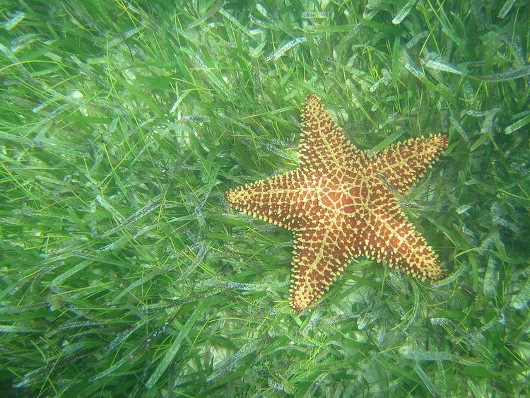
The STXEEMP encompasses seagrass meadows, shallow-water linear coral reefs (<10m), mid water (>10 m) patch coral reefs and deep mesophotic coral reefs (>30m). The shoreline boundaries of STXEEMP include numerous beaches, salt ponds and mangrove habitats. Great Pond, located at the southwestern shoreline boundary, is one of the largest remaining mangrove tracts on the island.
The seagrass meadows (principally composed of the seagrass species Thalassia testudinum and Syringodium filiforme) provide nursery and foraging areas for a variety of species of reef fish, stingrays, conch and other invertebrates. Seagrass beds also serve to anchor sand, and retain nutrients and sediment that wash down from the land.
Reefs provide shelter and foraging habitat for reef species, many of which are commercially important, either as a tourist attraction, a fishery or both. Mangroves serve as nurseries and shelter for juvenile fish, a catchment and filter for runoff and sediments, and provide critical shoreline protection from strong weather events. The mangrove habitat of Great Pond in particular also supports a large diversity of wintering shorebirds, and nesting habitat for resident species such as Least Tern Sterna antillarum, White-crowned Pigeons Patagioenas leucocephala (IUCN Near Threatened), Green-throated Carib Eulampis holosericeus, and a diversity of heron, egret and shorebird species.
Several commercially harvested species such as Queen Conch Strombus gigas, lobster Panulirus argus, whelk Cittarium pica, snapper Lutjanidae, grouper Serranidae and parrotfish Scaridae occur in STXEEMP. These species, and many others, are managed for sustainability and protected from harvest in certain areas (see below: No Take Zones).
Corals
Worldwide, Acropora corals are important reef-building species; in the Caribbean, Elkhorn Acropora palmata and Staghorn Acropora cervicornis have historically been the dominant species. Disease, in both corals and herbivorous sea urchins Diadema antillarum, coupled with rising seawater temperatures, have led to significant declines in coral cover and abundance throughout the Caribbean over the last half-century. Both of these Acropora species are currently found within STXEEMP; although their distribution is now patchy. These two species were listed as Threatened under the Endangered Species Act in 2006. A wide variety of other stony corals and soft corals also constitute the reef structures within STXEEMP.
Selected coral species in STXEEMP and their national/international status as of 2016:
Turtles
St. Croix is a significant nesting ground for Leatherback (Dermochelys coriacea IUCN Vulnerable), green (Chelonia mydas IUCN Endangered) and hawksbill (Eretmochelys imbricata IUCN Critically Endangered) sea turtles; Green and Hawksbill turtles also forage in the island’s waters
These three species of sea turtles (leatherback, green and hawksbill) nest on beaches fringing STXEEMP. Technical partners, including The Nature Conservancy and St. Croix Environmental Association, conduct nest monitoring on several of these beaches. The easternmost beaches on the south shore (East End, Isaac, and Jack Bays) are important nesting grounds for green and hawksbill turtles from August through November. In 2015, 7 green turtles nesting on these beaches were fitted with satellite tags to track their movements; follow their progress at seaturtle.org. Turtles are federally protected under the Endangered Species Act and also under Territorial provisions; harassment and/or possession of any species of sea turtle or their eggs is not permitted. Federal and Territorial fines apply.
Rules and Regulations
STXEEMP is managed with multiple-use zoning regulations in order to provide for a variety of legal uses. There are 4 zones: Recreational, No Take, Turtle Wildlife Preserve, and Open Fishing. Only 8.6% of STXEEMP’s area is completely off-limits to fishing. A Storymap produced in 2016 shows these zones.
* On the Northshore, from Green Cay to Cottongarden Point, this area extends from 100 ft from shore to 300 ft beyond the reef.
* From Cottongarden Point to Grapetree Point (around Point Udall) this area is from the beach to 300 ft beyond the reef.
* On the south shore, this area extends from 100 ft from shore to 300 ft beyond the reef, and is in effect from Grapetree Point to Milord Point.
Further Information and links
Neighbors and Partners
Scientific Studies and Further Information
Publications
St. Croix Geology