
Country United States FIPS code 01-72600 Elevation 221 m Zip code 35146 Local time Thursday 8:00 AM | Time zone Central (CST) (UTC-6) GNIS feature ID 0164863 Area 16.6 km² Population 4,200 (2013) Area code 205 | |
 | ||
Weather 18°C, Wind S at 10 km/h, 93% Humidity | ||
Help springville alabama traffic speeding ticket lawyer best springville al traffic attorney
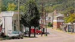
Springville is a city in St. Clair County, Alabama, United States. It incorporated in December 1880. At the 2010 census the population was 4,080, up from 2,521 in 2000.
Contents
- Help springville alabama traffic speeding ticket lawyer best springville al traffic attorney
- Map of Springville AL USA
- Geography
- Demographics
- 2010 census
- Movies
- Notable people
- References
Map of Springville, AL, USA
Help springville alabama traffic speeding ticket lawyer best springville al traffic attorney
Geography
Springville is located at 33°46′8″N 86°28′16″W (33.768950, −86.471037).
According to the U.S. Census Bureau, the town has a total area of 6.4 square miles (17 km2), of which 6.4 square miles (17 km2) is land and 0.04 square miles (0.10 km2) (0.31%) is water.
Demographics
As of the census of 2000, there were 2,521 people, 990 households, and 767 families residing in the town. The population density was 393.8 people per square mile (152.1/km²). There were 1,049 housing units at an average density of 163.8 per square mile (63.3/km²). The racial makeup of the town was 90.56% White or Anglo-American, 7.74% Black or African American, 0.16% Native American, 0.28% Asian, 0.16% Pacific Islander, and 1.11% from two or more races. 0.24% of the population were Hispanic or Latino of any race.
There were 990 households out of which 34.4% had children under the age of 18 living with them, 62.8% were married couples living together, 11.5% had a female householder with no husband present, and 22.5% were non-families. 20.5% of all households were made up of individuals and 8.3% had someone living alone who was 65 years of age or older. The average household size was 2.55 and the average family size was 2.93.
In the town the population was spread out with 24.9% under the age of 18, 6.9% from 18 to 24, 30.1% from 25 to 44, 26.2% from 45 to 64, and 11.9% who were 65 years of age or older. The median age was 38 years. For every 100 females there were 97.4 males. For every 100 females age 18 and over, there were 88.5 males.
The median income for a household in the town was $43,397, and the median income for a family was $53,859. Males had a median income of $35,977 versus $25,542 for females. The per capita income for the town was $20,518. About 8.0% of families and 10.8% of the population were below the poverty line, including 11.1% of those under age 45–55 and 23.4% of those age 65 or over.
2010 census
As of the census of 2010, there were 4,080 people, 1,561 households, and 1,223 families residing in the town. The population density was 637.5 people per square mile (245.8/km²). There were 1,652 housing units at an average density of 258.1 per square mile (99.5/km²). The racial makeup of the town was 93.6% White, 4.7% Black or African American, 0.3% Native American, 0.4% Asian, 0.1% Pacific Islander, and .9% from two or more races. 0.7% of the population were Hispanic or Latino of any race.
There were 1,561 households out of which 31.5% had children under the age of 18 living with them, 66.0% were married couples living together, 9.5% had a female householder with no husband present, and 21.7% were non-families. 19.3% of all households were made up of individuals and 8.1% had someone living alone who was 65 years of age or older. The average household size was 2.61 and the average family size was 2.98.
In the town the population was spread out with 23.8% under the age of 18, 6.7% from 18 to 24, 22.9% from 25 to 44, 32.3% from 45 to 64, and 14.3% who were 65 years of age or older. The median age was 42.6 years. For every 100 females there were 95.3 males. For every 100 females age 18 and over, there were 95.7 males.
The median income for a household in the town was $66,667, and the median income for a family was $75,679. Males had a median income of $60,893 versus $31,782 for females. The per capita income for the town was $27,526. About 7.9% of families and 9.2% of the population were below the poverty line, including 11.6% of those under age 18 and 9.9% of those age 65 or over.
Movies
Although a small Alabama town, Springville has been the site of filming for two movies: