
Primary inflows Surface elevation 1,701 m Length 14.8 km Year built 1950 | First flooded 1950 Area 19.9 km² Province Alberta | |
 | ||
Similar Rocky Mountains, Canadian Rockies, Spray River, Grassi Lakes, Can Nordic Centre Pr | ||
Read s ridge trip in kananaskis near spray lakes reservoir
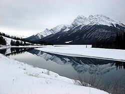
Spray Lakes Reservoir is a reservoir in Alberta, Canada. The Spray Lakes were a string of lakes formed along the Spray River, a tributary of the Bow River. With the damming of the river, the lakes were united in the Spray Lakes Reservoir.
Contents
- Read s ridge trip in kananaskis near spray lakes reservoir
- Map of Spray Lakes Reservoir Kananaskis AB Canada
- ParksEdit
- References
Map of Spray Lakes Reservoir, Kananaskis, AB, Canada
It lies between the Goat Range and the Three Sisters ridge, at an elevation of 1,720 meters (5,640 ft). The lake is followed by Highway 742 (Smith Dorrien Trail) in the northern part.
The lake is fed by the following waterways:
The lake is drained by the Spray River, which empties into the Bow River 10 kilometers (6.2 mi) downstream, at the town of Canmore.
ParksEdit
The lake lies in the recreational area of Kananaskis Country, and defines the eastern edge of Spray Valley Provincial Park. An assortment of recreational areas are established on both shores.
The western shore is paralleled by hiking trails, and picnic sites and campgrounds are set up on both sides of the lake.