
Elevation 430 m Local time Thursday 1:44 AM | Area 24.94 km² | |
 | ||
Weather 10°C, Wind NW at 13 km/h, 75% Humidity Points of interest Sivá Brada, St Martin's Cathedral, Rhythms of Life Land Art Project | ||
Spi sk podhradie 1968
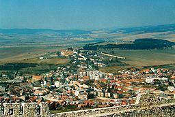
Spišské Podhradie (German: Kirchdrauf; Hungarian: Szepesváralja) is a town in Spiš in the Prešov Region of Slovakia. Its population is 3,826.
Contents
- Spi sk podhradie 1968
- Map of 053 04 SpiC5A1skC3A9 Podhradie Slovakia
- Dss spi sk podhradie
- Twin towns Sister cities
- References
Map of 053 04 Spi%C5%A1sk%C3%A9 Podhradie, Slovakia
Spišské Podhradie is situated at the foot of the hill of Spiš Castle. It had a Zipser German settlement, with its own church and priest, in 1174. Just above, and adjacent to, the town is the ecclesiastical settlement of Spišská Kapitula (hence an old German name Kirchdorf, meaning "church town"). The town contains a number of Renaissance merchants' houses. It also has one of the few remaining synagogue buildings (now disused) in the region.
Dss spi sk podhradie
Twin towns — Sister cities
Spišské Podhradie is twinned with:
References
Spišské Podhradie Wikipedia(Text) CC BY-SA