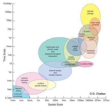
Spatial scale
In sciences such as physics, geography, astronomy, meteorology and statistics, the term scale or spatial scale is used for describing or classifying with large approximation the extent or size of a length, distance or area studied or described. For instance, in physics an object or phenomenon can be called microscopic if too small to be visible. In climatology, a micro-climate is a climate which might occur in a mountain, valley or near a lake shore, whereas in statistics a megatrend is a political, social, economical, environmental or technological trend which involves the whole planet or is supposed to last a very large amount of time.
In physics, the concept of scale is closely related to the more accurate concept of order of magnitude.
These divisions are somewhat arbitrary; where, on this table, mega- is assigned global scope, it may only apply continentally or even regionally in other contexts. The interpretations of meso- and macro- must then be adjusted accordingly.