
Country Ukraine Established 1295 Time zone EET (UTC+2) Area 62 ha Province Lviv Oblast | District Staryi Sambir Raion Elevation/(average value of) 373 m (1,224 ft) Area code +380 3238 Postal code 82073 | |
 | ||
Spas (Ukrainian: Спас) is a village (selo) in the Staryi Sambir Raion, Lviv Oblast, of Western Ukraine. Its total area is 0.62 km2, and the population is around 493 people. The local government is administered by the Tershivska village council.
Contents
Map of Spas, Lvivska, Ukraine
Geography
The village is located in the mountainous terrain of the Staryi Sambir Raion along the left (west) bank of the Dniester River. This area is also known as the Carpathian Foothills. The village is located 6 kilometres (3.7 mi) from the district center of Staryi Sambir along Highway H13, which runs from Lviv–Sambir to Uzhhorod. The village is situated 99 kilometres (62 mi) from the regional center Lviv and 194 kilometres (121 mi) from the Ukrainian city of Uzhhorod.
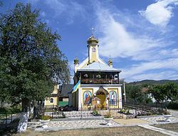
History and attractions
The village is known to have existed since at least the year 1295. In 1301, Knyaz Leo I of Galicia (ca. 1228 – ca. 1301) died in the town.
A few kilometers south of the village is a geological landmark called the Spassky Stone.
On July 28, 2013 a commemorative stone and memorable tablet was created and consecrated in the village of Spas to commemorate the 1025th anniversary of the baptism of Kievan Rus.