
- left Thistle Creek - location Provo Bay - average 237 cu ft/s (7 m/s) Mouth Utah Lake | - location Wasatch Range - elevation 4,495 ft (1,370 m) Basin area 1,748 km² Country United States of America | |
 | ||
- right Soldier Creek, Diamond Fork | ||
The Spanish Fork River or Spanish Fork is a river in the U.S. state of Utah. Formed by the confluence of Soldier Creek and Thistle Creek in the Wasatch Range, the river flows about 20 miles (32 km) northwest into Utah Lake, passing the towns of Spanish Fork and Palmyra.
Contents
- Map of Spanish Fork Utah USA
- Miracle how baby girl survived for 14 hours after car crashed into utah s spanish fork river
- Landslide damEdit
- References
Map of Spanish Fork, Utah, USA
Located entirely in Utah County (though a small portion of its drainage basin extends into Carbon County), the Spanish Fork is heavily used for irrigation. The Spanish Fork valley has been intensively farmed since Mormons first settled the region in the 1860s, but as the amount of agricultural land grew the river was no longer able to provide sufficient water except in years of heavy runoff. In 1909, the U.S. Bureau of Reclamation completed a tunnel to supplement the Spanish Fork's flow using water from the Strawberry River through the Strawberry Valley Project, part of the Central Utah Project.
Miracle how baby girl survived for 14 hours after car crashed into utah s spanish fork river
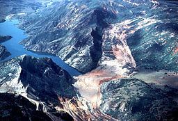
Landslide damEdit
In 1983, the river was catastrophically dammed by a landslide to a height of 220 feet (67 m). An 8-mile (13 km)-long lake formed behind the barrier, drowning the town of Thistle and a section of U.S. Route 89. The lake lasted for five months before a bypass project was completed to drain the water through a tunnel. This landslide is considered one of the most costly ever to have occurred in the United States.