
Population 212 (2006 census) Postal code 5454 | Postcode(s) 5454 Elevation 309 m Local time Wednesday 9:39 AM | |
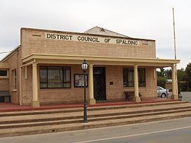 | ||
Established 1885 (district council proclaimed) Weather 16°C, Wind W at 19 km/h, 75% Humidity | ||
Spalding is a town located north of the Clare Valley in South Australia, Australia. At the 2006 census, Spalding had a population of 212.
Contents
Map of Spalding SA 5454, Australia
It is mainly a farming community and also is home to a slate quarry.
Services in the town include a supermarket, hotel, school, gun supplies store, roadhouse, CFS station, state emergency service (SES), dedicated post office and police station.
Spalding is presumed to be named after the market town of Spalding, Lincolnshire in the UK.
History
Prior to 1869, there were five sheep runs in the Spalding area: Bundaleer, Booborowie, Canowie, Hill River and Bungaree. From this date, the Spalding area was made available to farmers and a farming-centred community grew.
On 30 July 1885, the District Council of Spalding was proclaimed; it remained until 1997, when it merged into the Northern Areas Council. In 1925 a post office was built in Spalding.
Spalding was serviced by a broad gauge railway line through the Clare Valley from Adelaide from its construction in 1922 until the last train in 1978.
The historic Spalding Railway Bridge over the Broughton River and Bundaleer Reservoir site are both listed on the South Australian Heritage Register.