
 | ||
Stalker sd roll call new music video
As a geographic area, Southeast San Diego refers generally to the southeastern-most portion of the City of San Diego, and refers to those neighborhoods south of State Route 94 (Martin Luther King Jr. Freeway) and east of Downtown San Diego. There are three official community planning areas: Skyline-Paradise Hills, Encanto Neighborhoods, and Southeastern.
Contents
- Stalker sd roll call new music video
- Southeast san diego old school rappers
- Geography
- Political boundaries
- Neighborhoods
- Light rail
- Highways
- Demographics
- Image
- Landmarks
- Education
- Middle and junior high schools
- Senior high schools
- Atypical and other charter schools
- Artists
- Athletes
- Criminals
- Musical and performance artists
- Political figures
- Distinguished military veterans
- References
Largely urbanized in the areas nearer Downtown San Diego to the west and characteristically hilly, with lower-density residential and semi-rural neighborhoods toward the east, it is economically and ethnically diverse.
In 1992, Councilman George Stevens campaigned against any official usage of the name "Southeast San Diego," since the designation had long been viewed as shorthand for the community as being a crime-ridden and impoverished. His campaign was successful and all official use of "Southeast San Diego" has been discontinued by the city. Many residents and locals however, still refer to the area as "Southeast."
Southeast san diego old school rappers
Geography
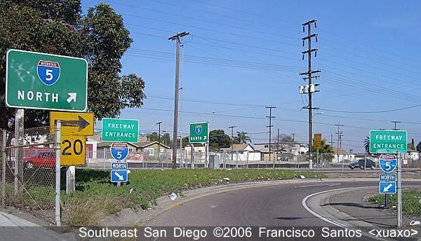
Historically, Southeast San Diego had been represented as the communities directly east of the downtown area which lies south of State Route 94 Martin Luther King Jr. Freeway, west of California State Route 125, east of Interstate 5, north of California State Route 54 and sharing its borders with surrounding cities of San Diego County National City to the south, Lemon Grove to the northeast, and Spring Valley to the east.
Political boundaries
The areas southeast of downtown San Diego include portions of Council Districts 4, 8 and 9 (Encanto Neighborhoods, Skyline-Paradise Hills, and Southeastern respectively).
Neighborhoods
Skyline-Paradise Hills Planning Area
Southeastern Planning Area
Encanto Neighborhoods Planning Area
Light rail
Highways
Demographics
Southeast San Diego is widely viewed as one of the most diverse areas in the city, inhabited most visibly by Latinos, African-Americans, and Filipinos. Estimates based on the neighborhoods spanning the 92102, 92113, 92114, and 92139 ZIP codes of Southeast San Diego put the population at roughly 195,000 people over an area of 21.2 square miles (55 km2), placing the area's population density at 9,285.7/sq mi (3,565.5/km²).
The area of Barrio Logan, for example, had been first settled by Mexicans arriving in the 1890s, followed soon after by refugees fleeing the violence of the Mexican Revolution and the poor Mexican economy between 1910 and 1920. Barrio Logan is predominantly Latino and is home to Chicano Park.
Prior to "White Flight" in the 1960s and early 1970s, many neighborhoods in Southeast San Diego were subject to discriminatory restrictive covenants, a problem faced by African-Americans like former Councilman and Deputy Mayor George Stevens, who was denied the opportunity to purchase a house in the Skyline Hills from a white realtor. Presently, much of the Skyline Hills, as well as other Encanto neighborhoods such as Emerald Hills, Lincoln Park, Mountain View, O'Farrell, South Encanto, and Valencia Park, have a substantial African-American population.
With the great influx of Filipino immigrants joining the United States Navy, especially from the Vietnam War era on to the 1990s, many Filipinos inhabited the Southeast San Diego neighborhoods of Alta Vista, Bay Terraces, Paradise Hills, Shelltown, Skyline Hills, and Valencia Park, both for the relatively affordable housing prices and its close proximity to Naval Base San Diego. During the 1980s, in the interest of urban renewal, an unused tract of land (formerly a canyon) between the Skyline and Paradise Hills neighborhoods underwent development. This tract would eventually become Bay Terraces. The notion of a new subdivision built directly triangulated in what were already considered high-crime areas repelled the great majority of home-buyers. The homes were also priced out of the range of typical residents of the area and most went unsold or, in some cases, unbuilt. Federal subsidies and economic programs were then employed to assist in completing and populating the subdivision. As a result, military personnel, Filipino immigrants with military ties, and low-income families were able to secure loans to buy the new homes in the area. The federally funded recovery project was only marginally successful, however, as several large portions of the development stood partially constructed and abandoned for nearly twenty years, the most noticeable example at the intersection of Skyline Dr. and Woodman Ave.
Additionally, enlisted military personnel (ranks E-1 to E-6) and their families occupy the Bayview Hills, a sprawling military housing complex operated by Lincoln Military Housing. This community of townhouse-style homes occupy a significant tract north of Paradise Hills adjacent to National City.
Demographics from Samuel F. B. Morse High School in the Skyline neighborhood alone provides a snapshot sample of the area's diversity with the school's 3,000 students characterized by a slim plurality of the students as Filipino (35%), followed by Hispanic-Latino (34%), Black (21%), and non-Hispanic White (4.0%). The latter statistic is most telling considering that as of 2000, US Census data indicates that non-Hispanic Whites alone represent 49.36% of the population of the City of San Diego. Additionally, roughly 63% of the student body is eligible for Free or Reduced-Price Lunch, a figure that reflects the working-class nature of the area.
Image
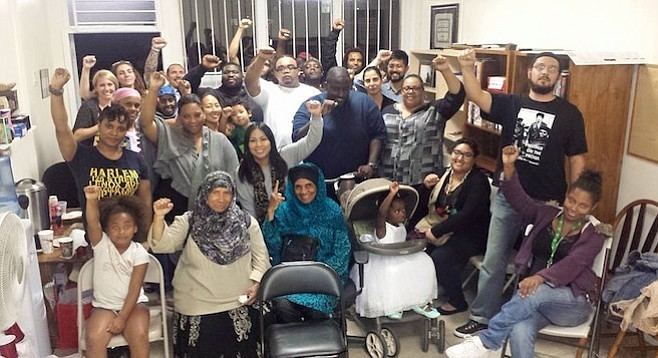
Southeast San Diego had long struggled with an image problem plagued by street gangs, drug dealing, assaults, and homicide throughout its communities. In 1992, Councilman George Stevens campaigned against any official designation of the area as "Southeast San Diego" since the name labeled the area in an entirely negative light.
The San Diego Police Department's Southeastern Division includes some of the city's peak crime areas including the neighborhoods of Encanto, Paradise Hills, Lincoln Park, Chollas View, Skyline, Shelltown, and Southcrest. Many of the inhabitants in these neighborhoods are working class or lower-income, and a typical sight that is evident throughout Southeast San Diego are homes outfitted with iron bars over the ground-floor windows and doors, and in many cases, cast-iron gates and chain-link fences guarding driveways, a reflection of the perceived need for security in these high-crime urban neighborhoods.
Although crime has gone down citywide, shootings are still a regular occurrence throughout Southeast San Diego, and the area routinely has a disproportionate amount of homicides in relation to the rest of the city. Additionally, many crimes in the area are not reported to the police which makes it difficult to give a completely accurate assessment on crime statistics in Southeast San Diego. Over the last few years, statistics from the San Diego Police Department show that about half of all homicides in the whole city had been accounted for in southeastern San Diego neighborhoods (covered by both the Central and Southeastern Districts), a substantial figure considering Southeast San Diego's relatively small geographic size and population in relation to the rest of the city. For example, in 2004, of the 62 homicides in the City of San Diego, 32 of them (roughly 16.4 murders per 100,000 residents or three times the national average of 5.5 murders per 100,000 for that year) had been accounted for in sixteen southeastern San Diego neighborhoods, from Barrio Logan to Lomita Village. In comparison, the northern San Diego suburb of Mira Mesa, which covers a substantial geographical area sizeable to Southeast San Diego's, 21.4 square miles (55 km2) to Southeast San Diego's 21.2 square miles (55 km2), had no homicides for that year.
The rash of violence in Southeast San Diego had been met with community outrage over the years and prompted a series of anti-violence marches and rallies. More recently in 2005, as a response to the spike in violence in the area, hundreds of middle school students took part in an anti-violence rally from the Lincoln Park area to Gompers Park in Chollas View, echoing chants of "Peace in Southeast" as they marched.
In 2010, the Southeast San Diego neighborhoods of Logan Heights and Lincoln Park were featured on The History Channel's Gangland television series. The show documented the Logan Heights Gang in the Season 6 episode titled "The Assassins," which first aired on February 19, 2010. Less than three months later, the Lincoln Park Bloods were featured on the Season 7 episode titled, "Vendetta of Blood" which first aired on May 14, 2010.
Landmarks
Education
The San Diego Unified School District oversees all public elementary, middle, junior and senior high schools in Southeast San Diego.
Middle and junior high schools
Senior high schools
The Southeast San Diego area is served primarily by three urban senior high schools.
Through the District's Voluntary Enrollment Exchange Program (VEEP), students from the Southeast San Diego community may be bused to high schools in San Diego's more affluent northern suburban neighborhoods, namely Mira Mesa High School, Mission Bay High School, Scripps Ranch High School, Serra High School, and University City High School.