
Population 66 (2011 census) Postcode(s) 3006 Area 25 ha Postal code 3006 | Established 2008 State electorate(s) Albert Park Founded 2008 | |
 | ||
Location 2 km (1 mi) from Melbourne LGA(s) City of Melbourne
City of Port Phillip Federal division Division of Melbourne Ports | ||
South Wharf is an inner suburb of Melbourne, Victoria, Australia, 2 km south-west of Melbourne's Central Business District. Its local government areas are the Cities of Melbourne and Port Phillip. At the 2011 Census, South Wharf had a population of 66.
Map of South Wharf VIC 3006, Australia
South Wharf is a small inner suburb south west from Melbourne's CBD. Its borders are the Yarra River to the north, Wurundjeri Way to the west, the West Gate Freeway and a small private car park bordering Ford Street and Munro Street, which is part of the City of Port Phillip, to the south and the former Port Melbourne railway line and Clarendon Street to the east.
Gazetted in 2008 and formerly part of the industrial and shipping area of Southbank, the renaming is part of a wider urban renewal strategy to link Southbank with the Melbourne Docklands.
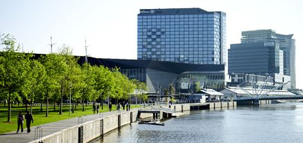
South Wharf includes some of Melbourne's landmarks, including the Melbourne Exhibition and Convention Centre and the Melbourne Maritime Museum, with its heritage Polly Woodside.
South Wharf is also home to many apartments, shopping outlet Direct Factory Outlets and the 5-star luxury hotel Hilton Melbourne - South Wharf.
A five-storey Victorian warehouse, known as the Tea House (at 28 Clarendon Street), built in 1888, is one of the few buildings which survived the redevelopment of the area.