
Country United States County Allegheny County Area 185 ha | State Pennsylvania City Pittsburgh Population 4,423 (2010) | |
 | ||
Restaurants UUBU 6, Gabriella's Gourmet, Mamma Mia Pizzeria, Pats Lunch | ||
History
In 1763, King George III of England granted John Ormsby, a soldier in the French and Indian War as well as the alleged first settler of Pittsburgh, 2,400 acres of land along the southern banks of the Monongahela River for his service in the capture of Fort Duquesne. Ormsby divided the land into four boroughs - South Pittsburgh, Birmingham, Ormsby, and East Birmingham, which is present day South Side Slopes.
Contents
South Side expanded and grew in order to keep up with Pittsburgh's industrial boom, adopting the nickname "Workshop of the World". The industry of glass-making was predominant in the early 1800s, and later the banks of the Monongahela River became home to the iron and steel operations run by the company J&L Steel.
J&L (The Jones and Laughlin Steel Company) eventually became South Side's largest employer as by 1910 it employed 15,000 workers. The majority of these workers came as immigrants from European nations such as Germany, Ireland, Poland, Lithuania, the Ukraine, and the Slavic nations and settled into homes in the present day South Side Slopes. The houses built for them were traditionally one room wide, two rooms deep, and up to four stories high. The houses are built into the hillside with narrow walkways between them. Most of the structures and houses in both South Side Slopes are balloon-framed whereas many of those on the South Side Flats were built from brick, in a rectangular fashion. Many of them were ornamented in the popular style of the 1900s - Romanesque, Italianate and Second Empire. They are fashioned in a classical Victorian style row home way with carved doorways, cornices, corbelling, cast iron ornaments and geometric slate patterns. The Slopes is rich in culture as many immigrants wanted to preserve their native cultures and languages; so they built many bars and churches, many of which still exist today.
Geography
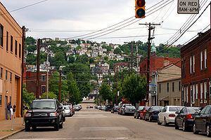
South Side Slopes is located at 40.42 N and 79.97 W. The area South Side Slopes covers is approximately 0.716 square miles (1.85 km2) or 460.632 acres. It is made up of many slopes with elevations ranging from 791 feet (241 m) to 1,174 feet (358 m). There are some areas that are too difficult for automobile navigation so the numerous staircases located throughout South Side Slopes serve as the "streets". There have been approximately 70 sets of staircases found in the neighborhood.
South Side Slopes is part of District 3 in Allegheny County. South Side Slopes is surrounded by the neighborhoods of Allentown, Arlington, Arlington Heights, Knoxville, Mt. Washington, South Shore, and South Side Flats. It also borders the borough of Mt. Oliver. 18th Street, Arlington Avenue, and Josephine Street are two of the main roads that run through the neighborhood. It is approximately 2.8 miles (4.5 km) from the Monongahela River and the historic Birmingham Bridge. The Slopes neighborhood is also close to the diverse East Carson Street and the SouthSide Works shopping center.
South Side Slopes has an overall cold climate, meaning it has about 5,400 heating degree days and fewer than 9,000 heating degree days based on a temperature of 65 degrees Fahrenheit. It can experience temperatures that range from 90 degrees Fahrenheit to negative 10 degrees Fahrenheit. The area also accumulates an average of 30 to 40 inches of precipitation per year. Allegheny County can also get anywhere from zero to five to twenty inches of snow per month during the months of December, January, February, and March.
Demographics
According to the 2010 census, there were 5,007 people living in the neighborhood and 2,580 total housing units within its boundaries. The racial makeup of the neighborhood was 88.54% White, 7.14% African American, 0.95% Asian, 1.06% from other races, and 2.31% from two or more races. Hispanics and Latinos of any race were 2.1% of the population.
Out of the total number of housing units, 83.5% were occupied. The owner occupancy percentage is 61.2%. There were 12.23% of households with those under the age of 18 and 18.34% with those over the age of 60.
The population was generally decreasing with 15,083 in 1940; 12,998 in 1950; 10,842 in 1960; 9,739 in 1970; 7,020 in 1980; 5,007 in 2000.