
Norse name Hafrey OS grid reference HU360268 Highest elevation 42 m | Meaning of name "Ewe Island" Area rank 183= Area 59 ha Lieutenancy area Shetland | |
 | ||
South Havra (Old Norse: Hafrey) is an uninhabited island in the Scalloway Islands, Shetland, Scotland.
Contents
Map of South Havra, United Kingdom
Geography and geology
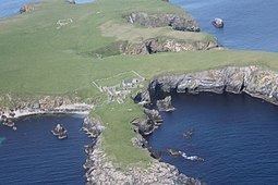
South Havra lies south of Burra and west of the southern peninsula of the Mainland, Shetland.
The island's rock is "epidiotic syenite with undifferentiated schist and gneiss."
The soil is fairly fertile, but the lack of running water meant that, unusually for Shetland, the islanders resorted to building a windmill to grind corn.
Geological features on the island include caves and natural arches
Little Havra is to its west.
History
Olaf Sinclair, foud (a kind of magistrate) of all Shetland lived here in the 16th century.
The island's ruined windmill is an unusual sight in the Shetland Islands, especially as some have pointed out, that the Dutch were amongst the archipelago's most frequent visitors.
South Havra has been uninhabited since May, 1923. Previously the population was big enough to support a school.