
- elevation 1,302 ft (397 m) | - elevation 2,071 ft (631 m) | |
 | ||
- location | ||
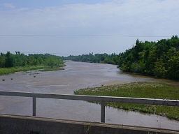
The South Fork Ninnescah River is a river in the central Great Plains of North America. Its entire length lies within the U.S. state of Kansas. It is a tributary of the Ninnescah River.
Contents
Map of South Fork Ninnescah River, Kansas, USA
Geography
The South Fork Ninnescah River originates in south-central Kansas in the High Plains. Its source lies in west-central Pratt County approximately 2 miles (3.2 km) southwest of Cullison, Kansas. From there, it flows generally east into the Wellington Lowlands. In southwestern Sedgwick County, it meets the North Fork Ninnescah River to form the Ninnescah River.
References
South Fork Ninnescah River Wikipedia(Text) CC BY-SA