
 | ||
Similar Lefka Ori, Karga, Samariá Gorge, Lake Kournas, Old Venetian Harbour | ||
Naval support activity souda bay port brief
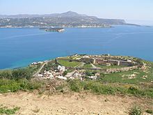
Souda Bay is a bay and natural harbour near the town of Souda on the northwest coast of the Greek island of Crete. The bay is about 15 km long and only two to four km wide, and a deep natural harbour. It is formed between the Akrotiri peninsula and Cape Drapano, and runs west to east. The bay is overlooked on both sides by hills, with a relatively low and narrow isthmus in the west near Chania.
Contents
- Naval support activity souda bay port brief
- Welcome to nsa souda bay arrival and policies
- Ancient and MedievalEdit
- Venetian ruleEdit
- Ottoman ruleEdit
- Cretan State 18981913Edit
- Union with Greece to WW II 19131940Edit
- 19401945Edit
- Military installationsEdit
- Philately and Postal historyEdit
- References
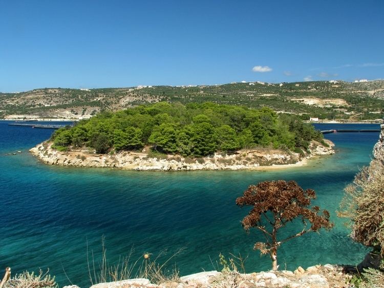
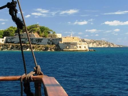
Near the mouth of Souda bay, between the Akrotiri and the town of Kalives, there is a group of small islands with Venetian fortifications. The largest island is Souda Island, giving its name to the bay.
Souda Bay is now a popular tourist destination although there are no real public beaches due to the presence of the Crete Naval Station. Villages such as Megala Chorafia and Kalives afford fine views of the bay, and house-building, particularly for foreigners and tourist companies, is spreading along the bay.
Welcome to nsa souda bay arrival and policies
Ancient and MedievalEdit
There have been port facilities on the bay since ancient times, previously serving the city of Aptera. Aptera was founded in the 7th Century BC and was an important city during the ancient and early Byzantine periods. It was destroyed by the Saracens in the 820s AD. The nearest large ancient city was Kydonia, which flourished in the Minoan era on Crete; moreover, during a portion of the first millennium BC Kydonia held influence over Aptera.
Venetian ruleEdit
The Venetians occupied the area in 1207. In 1571 an Ottoman military force landed at Souda and caused major destruction in the Chania area. The Venetians fortified Souda Island between 1570 and 1573, in order to protect the area from Ottoman raiders and pirates. However, Souda Bay remained a pirate infested area during the 15th, 16th and 17th centuries. The Venetians managed to hold on to the strategic islands within Souda Bay until 1715, over thirty years after the fall of Crete to the Ottomans.
Ottoman ruleEdit
In 1822 an Egyptian army of approximately 10,000 under Hassan Pasha landed at Souda to defeat the Cretan Revolution of 1821.
After the Cretan Revolution of 1866–69, the Ottomans built fortresses at Aptera (Aptera Fortress) and Kalami (Izzeddin Fortress), barracks, a military hospital and a naval base. They also built the town of Souda at the head of the bay, as the new port of the nearby city of Chania. The fortress at Kalami is still in use as prisons. The naval base was officially inaugurated in 1872, in the presence of Sultan Abdul Aziz.
Cretan State (1898–1913)Edit
In the period of the semi-independent Cretan State the area attracted international interest, as it offered port facilities to foreign naval vessels enforcing the Cretan autonomy. The first High Commissioner, Prince George of Greece, disembarked at Souda Bay on December 9, 1898. The church of Saint Nicholas was built during this period.
Union with Greece to WW II (1913–1940)Edit
In 1913, events marking the union of Crete with Greece took place on Souda Island. On February 1 the metallic Ottoman flag, the last symbol of Ottoman rule, was removed and replaced by the Greek flag on May 1. Also the ruined chapel was rebuilt and dedicated to Saint George.
In 1916 the British liner SS Minnewaska, requisitioned by the British Army as a troops carrier, struck a mine and was beached at Souda Bay.
After 1923 the area was used as an Hellenic Army base, housing the artillery units of 5th Infantry Division.
1940–1945Edit
During World War II British and Commonwealth troops withdrew from mainland Greece in April 1941 and 25,000 men, mainly from New Zealand and Australia, disembarked at Souda Bay.
In May 1941, during the German attack named "Operation Merkur", Allied troops retreated from the Souda area to Sfakia in the south of the island. The Germans occupied the area until 1945. The Souda Bay Allied War Cemetery, the principal Allied war cemetery of the island, designed by architect Louis de Soissons, is located at Souda.
Military installationsEdit
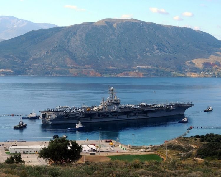
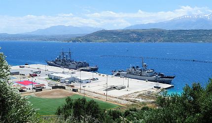
Souda Bay is the location of three major military installations: the Hellenic Navy's Crete Naval Station, which also houses the NATO Maritime Interidiction Operational Training Centre; the Hellenic Air Force's Souda Air Base on Akrotiri Peninsula, base of the 115th Combat Wing; and the NATO Missile Firing Installation.
Philately and Postal historyEdit
During Turkish rule an Ottoman post office operated in Souda until 1892. The Cretan State post office opened officially in 1912, although a postal agent operated there previously, possibly since 1908.
A special local stamp depicting Souda Island was issued on November 15, 1913 to commemorate the union with Greece and was sold only by Cretan post offices. This stamp, printed by Bradbury Wilkinson and Company in the United Kingdom, is commonly called the "Souda Issue".