
Country Hungary County seat Kaposvár Area code(s) (+36) 82, 84, 85 University University of Kaposvár | Region Southern Transdanubia Area rank 5th in Hungary Area 6,065 km² | |
 | ||
Postal code 7253 – 729x, 74xx – 75xx, 7918, 7977 – 7979, 86xx – 873x, 884x – 885x Clubs and Teams Kaposvári Rákóczi FC, Siófok KC, Csurgói KK, BFC Siófok, Kaposvári KK, Barcsi SC, Somogy FC Points of interest Lake Balaton, Krisna‑völgy IKKB, Napfény Strandfürdő, Zamárdi Kalandpark, Balatonlellei Vidámpark Destinations Lake Balaton, Siófok, Balaton Uplands National, Danube‑Drava National Park, Kaposvár | ||
Somogy (Slovene: Šomodska županija) is an administrative county (comitatus or megye) in present Hungary, and also in the former Kingdom of Hungary.
Contents
- Map of Somogy County Hungary
- Somogy county
- History
- Demographics
- Ethnicity
- Religion
- Politics
- Cities with county rights
- Towns
- Villages
- References
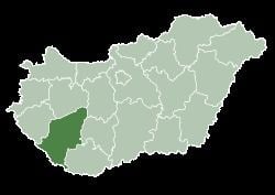
Map of Somogy County, Hungary
Somogy county
Somogy county lies in south-western Hungary, on the border with Croatia. It stretches between the river Dráva and the southern shore of Lake Balaton. It shares borders with the Hungarian counties Zala, Veszprém, Fejér, Tolna, and Baranya. It is the most sparsely populated county in Hungary. The capital of Somogy county is Kaposvár. Its area is 6,036 km².
History
Somogy was also the name of a historic administrative county (comitatus) of the Kingdom of Hungary. Its territory, which was slightly larger than that of present Somogy county, is now in south-western Hungary. The capital of the county was Kaposvár.
Demographics
In 2015, it had a population of 312,084 and the population density was 52/km².
Ethnicity
Besides the Hungarian majority, the main minorities are the Roma (approx. 16,000), Germans (3,000) and Croats (1,500).
Total population (2011 census): 316,137
Ethnic groups (2011 census):
Religion
Religious adherence in the county according to 2011 census:
Politics
The Somogy County Council, elected at the 2014 local government elections, is made up of 16 counselors, with the following party composition:
Cities with county rights
Towns
(ordered by population, as of 2011 census)
Villages
municipalities are large villages.