
- location Cawker City, Kansas - location Solomon, Kansas Basin area 17,703 km² Mouth Smoky Hill River | - elevation 1,453 ft (443 m) - elevation 1,142 ft (348 m) Source Waconda Lake Country United States of America | |
 | ||
- left North Fork Solomon River - right South Fork Solomon River | ||
Osborne kansas solomon river in january
The Solomon River, often referred to as the "Solomon Fork", is a 184-mile-long (296 km) river in the central Great Plains of North America. The entire length of the river lies in the U.S. state of Kansas. It is a tributary of the Smoky Hill River.
Contents
- Osborne kansas solomon river in january
- Map of Solomon River Kansas USA
- NamesEdit
- GeographyEdit
- HistoryEdit
- In literatureEdit
- References
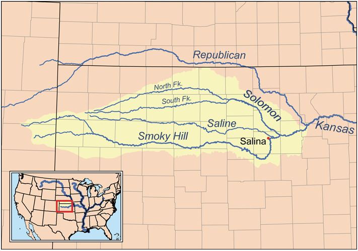
Map of Solomon River, Kansas, USA
NamesEdit
The Native name for the river was Nepaholla, meaning "Water on the Hill" in reference to Waconda Spring which was located in the river valley. In 1744, French explorers named the river Salmon, later corrupted into Solomon, after Edme Gatien de Salmon, a prominent colonial official of French Louisiana at the time. Other names for the river include Mahkineohe, Riviere de Soucis, Solomons Creek, Wiskapalla River, and Solomons Fork.
GeographyEdit
The Solomon River is formed by the confluence of the North Fork Solomon River and South Fork Solomon River at Waconda Lake in northwestern Mitchell County, Kansas. Both forks originate in the High Plains of northwestern Kansas. From Waconda Lake, the Solomon flows southeast for 184 miles (296 km) through the Smoky Hills region and joins the Smoky Hill River immediately south of Solomon, Kansas in western Dickinson County.
The Solomon River drainage basin covers an area of 6,835 square miles (17,703 km2). Via the Smoky Hill, Kansas, and Missouri Rivers, it is part of the Mississippi River watershed.
Kansas towns along the Solomon River include Cawker City, Beloit, and Minneapolis.
HistoryEdit
Before American colonization, the Solomon River valley was a popular hunting and trapping area for the Plains Indians. Tribes that camped along the river included the Pawnee, Cheyenne, and Kansa. French explorer Etienne Venyard de Bourgmont visited the area in 1712, claiming it for France. Other French explorers returned in 1744 to survey the area and gave the river its name. With the Louisiana Purchase in 1803, the region became part of the territory of the United States. In 1806, explorer Zebulon Pike led an expedition through the area, camping on the Solomon's North Fork near the site of modern Downs, Kansas. American settlers began to arrive in the 1850s, hunters and trappers initially followed by homesteaders. In 1861, the area became part of the state of Kansas.
In 1969, the U.S. Bureau of Reclamation finished construction of Glen Elder Dam, a dam for flood control immediately above Glen Elder, Kansas on the Solomon River, creating Waconda Lake.