
Country Philippines Barangays ZIP code 3503 Province Cagayan | District 3rd District Time zone PST (UTC+8) Area 234.6 km² Local time Sunday 7:13 AM | |
 | ||
Region Cagayan Valley (Region II) Weather 24°C, Wind NW at 3 km/h, 93% Humidity Neighborhoods Ipil, Gadu, Nabbotuan, Atulayan, Barung | ||
Solana is a first class municipality in the province of Cagayan, Philippines. According to the 2015 census, it has a population of 82,502 people.
Contents
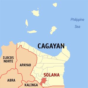
- Map of Solana Cagayan Philippines
- Barangays
- Demographics
- Government
- Elected officials for the term of 20162019
- References
Map of Solana, Cagayan, Philippines
Barangays
Solana is politically subdivided into 38 barangays.
Demographics
In the 2015 census, the population of Solana, Cagayan, was 82,502 people, with a density of 350 inhabitants per square kilometre or 910 inhabitants per square mile.
Government
The Sangguniang Panlungsod is composed of the City (Municipality) Vice-Mayor as Presiding Officer, regular Sanggunian members (Councilors), the President of the Association of Barangay Captains and the President of the Sangguniang Kabataan. They shall exercise and perform the legislative powers and duties as provided for under Republic Act No. 7160, otherwise known as the Local Government Code of 1991. Shall consider and conduct thorough study all matters brought to their attention and consequently pass resolutions, enact ordinances and to introduce recommendations.
Elected officials for the term of 2016–2019
Councilors: