
Population 50 ish | Area 3.5 km² | |
 | ||
Islands North East Island, New Zealand, Broughton Island, New Zealand, Western Chain, New Zealand | ||
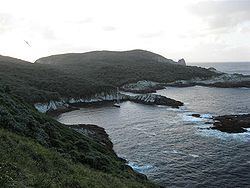
Snares Islands/Tini Heke, also known as The Snares, is a small island group lying about 200 km south of New Zealand's South Island and to the south-southwest of Stewart Island/Rakiura. The Snares consist of the main North East Island and the smaller Broughton Island as well as the Western Chain Islands some 5 km (3.1 mi) to the west-south-west. Collectively, the Snares have a total land area of 3.5 km2 (1.35 sq mi).
Contents
Map of Snares Islands, New Zealand
History
The island group was first sighted by Europeans on 23 November 1791 independently by the two ships HMS Discovery under Captain George Vancouver, and HMS Chatham commanded by Lieutenant William R. Broughton, both of the Vancouver Expedition. Vancouver named the islands "The Snares" because he considered them a shipping hazard; an islet east of the Western Chain bears the name Vancouver Rock, and the second largest island is named after Broughton.
The islands were already known to the Māori, who called one of the larger islands Te Taniwha ("The sea-monster"). Unlike other subantarctic islands that were greatly affected by the whaling and sealing industry in the 19th century, the Snares remain one of the last pristine areas in New Zealand.
The Ngai Tahu Claims Settlement Act 1998 officially altered the name to "Snares Islands/Tini Heke" — one of many such changes under the Ngāi Tahu Treaty settlement.
Geography
The main island of the Snares group, North East Island, as its name suggests, lies at the northeastern corner of the group. It has roughly the shape of a triangle, but with two concave edges, this causing both the southern and northwestern coast to be in the form of large irregular bays. Cliffs and reefs are found along the northeastern coast and part of the southern coast, with the islands highest point – rising to 130 metres – being located on the long westward-pointing finger which lies between them.
In contrast, the east coast is relatively flat and sloping, and provides the only easy access-point for landing, close to Station Point. Several small bays dot the east coast, among them Punui Bay, Ho Ho Bay, and Mollymawk Bay. The island's northernmost and southernmost points are the prosaically named North Promontory and South Promontory. Several small islets, the Daption Rocks, lie off the tip of North Promontory, and are the island group's northernmost point.
The group's second largest island, Broughton Island, lies to the southeast of South Promontory. Steeply sloping, it is surrounded by cliffs, reefs and small islets on three sides, with only the northern side being relatively accessible.
The long finger on the western coast of the main island has several small islands located close to its tip. The largest of these, Alert Stack, is located to the south of the peninsula and separated from it by a narrow channel. The peninsula points almost directly towards the Western Chain, a line of stacks located some 4 kilometres to the southwest of the main island. These islets are simply names Tahi, Rua, Toru, Wha, and Rima, the Māori words for the numerals one to five. Between this chain and North East island lies the small stack of Vancouver Rock.
Environment
The islands provide a home to endemic bird species such as the Snares penguin (Eudyptes robustus), the Snares snipe (Coenocorypha huegli) and Snares tomtit (Petroica macrocephala dannefaerdi), as well as to several endemic invertebrates. North East Island is forested and is the world's premier breeding area for the sooty shearwaters (Puffinus griseus) with up to 3 million individuals being present during the breeding season (November–April). A dangerous reef (Seal Reef) lies ten kilometres to the south of the group. Megaherb communities grow on the islands.
The islands enjoy a status of high protection and are rated by the New Zealand Department of Conservation as "minimum impact islands". Landing on the islands is generally prohibited or by special research permit only.
The area is among one of five subantarctic island groups forming the New Zealand Subantarctic Islands, designated as a World Heritage Site by UNESCO.