
Elevation 10,441 ft (3,182 m) Width 39 mi (63 km) E/W | Length 45 mi (72 km) N/S | |
 | ||
Mountains | ||
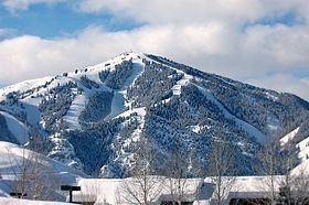
The Smoky Mountains are part of the Rocky Mountains and located on the west side of the Wood River Valley near Sun Valley, Idaho, in the Western United States. The range is within Sawtooth National Forest, while part of it is within the Sawtooth National Recreation Area. The highest point in the range is Saviers Peak at 10,441 ft (3,182 m).
The Smoky Mountains area closely surrounded by other mountain ranges including the Sawtooth Mountains to the northwest, Boulder Mountains to the north, Pioneer Mountains to the east, and Soldier Mountains to the south. The Smoky Mountains are located within the watersheds of the Big Wood, Salmon, and Boise Rivers. The mountains are most easily accessed from Idaho State Highway 75, although many unimproved and improved dirt road, including National Forest road 227, enter and cross the mountains.
The Smoky Mountains were named from the frequent forest fires in the mountains. In 2007 the Castle Rock Fire burned 48,000 acres (19,000 ha) of the Smoky Mountains near Ketchum.