
Country Canada Census division 12 Time zone MST (UTC-7) Elevation 610 m Local time Friday 2:03 PM | Municipal district Smoky Lake County Highways Highway 28Highway 855 Area 4.2 km² Population 964 (2016) | |
 | ||
Weather -2°C, Wind E at 23 km/h, 94% Humidity | ||
My new smoky lake maple pans 2016
Smoky Lake is a town in central Alberta, Canada. It is located 116 km (72 mi) northeast of Edmonton at the junction of Highway 28 and Highway 855. It lies between the North Saskatchewan River, Smoky Creek and White Earth Creek, in a mainly agricultural area. The provincial historic site of Victoria Settlement is nearby. Long Lake Provincial Park is located 60 km (37 mi) north of the town. Since time immemorial, the Wood Cree Indians named "Smoking Lake" for the smoke from ceremonies performed on the shore; the name Smoky Lake may also be based in the mist that rose from the lake in great quantities at sundown. One of its churches, the St. Onuphrius Ukrainian-Catholic, built in 1907, has been moved to the Canadian Museum of History in Ottawa.
Contents
- My new smoky lake maple pans 2016
- Map of Smoky Lake AB Canada
- Smoky lake hybrid evaporator
- Demographics
- Notable people
- References
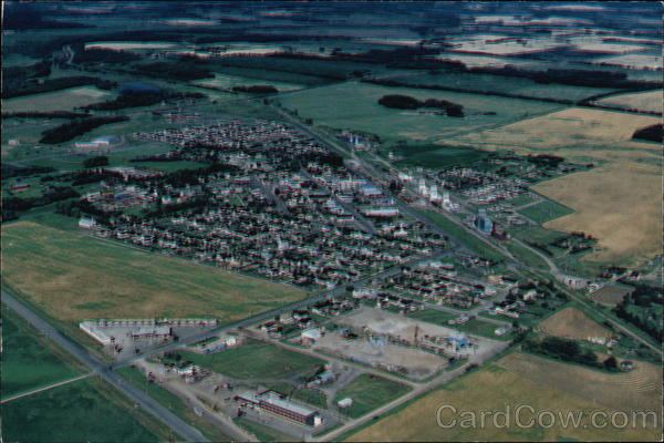
Map of Smoky Lake, AB, Canada
Smoky lake hybrid evaporator
Demographics
In the 2016 Census of Population conducted by Statistics Canada, the Town of Smoky Lake recorded a population of 964 living in 421 of its 499 total private dwellings, a 2999430000000000000♠−5.7% change from its 2011 population of 1,022. With a land area of 4.26 km2 (1.64 sq mi), it had a population density of 226.3/km2 (586.1/sq mi) in 2016.
In the 2011 Census, the Town of Smoky Lake had a population of 1,022 (living in 430 of its 478 total dwellings), a 1.2% change from its 2006 population of 1,010. With a land area of 4.2 km2 (1.6 sq mi), it had a population density of 243.3/km2 (630.2/sq mi) in 2011.