
Township West Lincoln Forward sortation area L0R 2A0 Elevation 198 m Population 4,491 (2011) | Time zone EST (UTC-5) NTS Map 030M04 Area 4.61 km² Area code Area code 905 Local time Friday 2:49 PM | |
 | ||
Weather 14°C, Wind SW at 18 km/h, 58% Humidity | ||
Smithville is a community in the township of West Lincoln. The former police village is located on Highway 20 between Hamilton and Niagara Falls in the Niagara Region of Ontario, Canada. Smithville is the largest town and governing centre of the township of West Lincoln.
Contents
- Map of Smithville ON Canada
- History
- Annual events
- Commerce
- Education
- Government
- Demographics
- Recreation
- Transportation
- References
Map of Smithville, ON, Canada
History
Smithville was first settled by Richard Griffin and his family, United Empire Loyalists who came from Nine Partners, New York in 1787. The names of his sons were Abraham, Edward, Nathaniel, Isaiah, Smith, Jonathan, and Richard Jr. They settled on Lots 8, 9, 10, Concession IX, on the Twenty Mile Creek in Grimsby (later South Grimsby) Township. Solomon Hill, who married Bethia, daughter of Richard Griffin, settled on Lot 6, Charles Meridith on Lot 7; Thomas Harris on Lot 11, and Thomas North on Lot 12. These lots, all in the 9th Concession became the settlement first known as Griffintown, but later renamed after Mrs. Griffin, whose maiden name was Mary Smith.
Edward "Ned" Griffin is sometimes claimed to be the real founder of the village. He was the one who felled the first tree, chose the village site, cleared the first acre of land, built the first house, and lived his entire life in the village. Another son, Smith Griffin, is credited with building a treadwheel in 1810. Settlers who wanted their grain ground were required to provide their own motive power by putting their oxen on the tread. Later, Smith Griffin built a dam and mill on the Twenty Mile Creek, making the treadmill obsolete. Smith also started an ashery, while his brother Edward opened a general store.
By 1849, Smithville had reached a population of about 150, and had been granted a post office with twice-weekly delivery. The settlement had a grist mill, a saw mill, a carding machine and cloth factory, four stores, one machine shop, one tannery, two blacksmiths, two tailors and two shoemakers.
Smithville first became a police village in 1887, however the arrangement was unsatisfactory and the village again became part of South Grimsby Township in 1889. It was not until 1914 that Smithville was reorganized into a police village on a more permanent basis. By the 1950s, the population had grown to approximately 1000 souls.
Smithville, along with the remainder of South Grimsby Township was amalgamated into the newly formed Township of West Lincoln on January 1, 1970.
Annual events
Although the town is small, it is known for the annual festival called PoultryFest Niagara. The festival is held annually on the third Saturday in June, and residents from various areas of the region visit to see the town's display of agricultural pride.
Smithville continues to hold an agricultural fair on the weekend after the Labour Day weekend every year. There are lots of agricultural competitions, demolition derbies and entertainment for all ages.
Commerce
Retail establishments in Smithville are congregated amongst two major nodes: the downtown core, and the Village Square Mall.
Major businesses downtown include Foodland, Royal Bank, CIBC and Rexall. It is also the location of several real estate, doctor, and financial adviser offices. Notable commercial establishments in the Village Square Mall include, a Giant Tiger, Home Hardware, Subway, Gino's Pizza, Tim Hortons, Beer Store, and a liquor store and Employment Help Centre.
Smithville also had a Farmers Market that ran every Saturday morning in the summer. The market featured a carefully selected variety of vendors showcasing local produce, preserves, meat, honey, flowers and baking. This market was cancelled after its 2013 run.
Education
Smithville has six schools, including four elementary and two secondary.
The elementary schools are College Street, St. Martin's, John Calvin, and Covenant Christian Schools.
South Lincoln High School is a public school, while Smithville Christian High School is a Christian secondary school.
Government
In some ways Smithville acts as the "administrative centre" of the Township of West Lincoln. The council chambers and the largest branch of the municipal library are located in town, as well as the major fire station. The public works yard is also centralized in a Smithville location.
Smithville falls into two municipal wards. The area north of Townline Road is part of Ward 3, the former Township of South Grimsby. Development south of Townline is part of Ward 2, the former Township of Gainsborough.
The Mayor of West Lincoln serves as the local representative on regional council.
Federally and provincially, Smithville is located in the riding of Niagara West-Glanbrook.
Demographics
Population:
Mother tongue:
Patron:
Recreation
Parks in Smithville include the Smithville Conservation Area, and the Smithville Fairgrounds and West Lincoln Arena.
The "Murgatroyd Parkette" is at the corner of Griffin and St. Catharines Street. It has trees and benches, and features the town clock (from the original post offices) mounted on a pedestal.
The Smithville Branch of the West Lincoln Public Library is located on Canborough St. and open six days a week.
Transportation
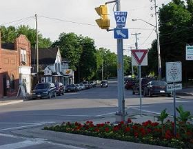
The major artery in Smithville, and West Lincoln as a whole, continues to be Highway 20. Highway 20 runs along West Street, Griffin Street North and St. Catharines Street through the town.
The major arteries include the aforementioned Griffin (downtown), St. Catharines (Highway 20 east of Griffin), and West (Highway west of Griffin) streets. Canborough Street and Station Street, the southern and northern extensions of Griffin Street, are designated as part of Regional Road 14. Townline Road is the major artery in the southern portion of town, and is also known as Smithville Road west of town. It is also designated as part of 14, up to the intersection with Canborough.
Smithville is located on Canadian Pacific's Hamilton Subdivision, and was formerly the location of a junction with the railroad's Dunnville spur. The latter was abandoned in 2003, and the tracks lifted. The former railroad station is a local landmark, and serves as the headquarters of the West Lincoln Historical Society.