
Location Oppland Surface area 11.29 km (4.36 sq mi) Area 11.29 km² Shore length 46.34 km | Surface elevation 366 m Mean depth 23 m | |
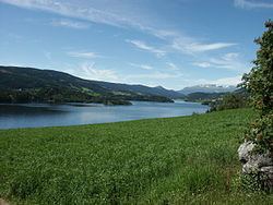 | ||
Slidrefjord (English: Slidre Fjord) is a lake which lies in the municipalities of Vestre Slidre and Vang in Oppland county, Norway. The lake is part of the Begna Watershed.
Map of Slidrefjord, Vestre Slidre, Norway
Slidrefjord has a surface area of 11.29 km² and a shore length of 46.34 km. It is at an elevation of 366 m above sea level.
References
Slidrefjord Wikipedia(Text) CC BY-SA