
Topo map NTS #052A07 Elevation 563 m | ||
 | ||
Similar Hillcrest Park, Mount McKay, Kakabeka Falls, Terry Fox Memorial and Look, Kaministiquia River | ||
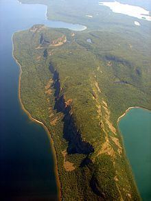
The Sleeping Giant is a formation of mesas and sills on Sibley Peninsula which resembles a giant lying on its back when viewed from the west to north-northwest section of Thunder Bay, Ontario, Canada. As one moves southward along the shoreline toward Squaw Bay the Sleeping Giant starts to separate into its various sections. Most distinctly in the view from the cliffs at Squaw Bay the Giant appears to have an "Adam's Apple". The formation is part of Sleeping Giant Provincial Park. Its dramatic steep cliffs are among the highest in Ontario (250 m). The southernmost point is known as Thunder Cape, depicted by many early Canadian artists such as William Armstrong.
Contents
Map of Sleeping Giant, Unorganized Thunder Bay District, ON, Canada
One Ojibway legend identifies the giant as Nanabijou, who was turned to stone when the secret location of a rich silver mine now known as Silver Islet was disclosed to white men.
Seven Wonders of Canada
It was voted number one for a list of Seven Wonders of Canada, with a total of 177,305 votes, beating the Bay of Fundy and Niagara Falls by almost 90 000 votes. Ultimately it was not selected by the panel of judges, Ra McGuire, Roberta Jamieson and Roy MacGregor, who decided their vote by geographic and poetic criteria.