
Country Sri Lanka Postal code 00200 Province Western Province | District Colombo District Local time Friday 6:26 AM | |
 | ||
Time zone Sri Lanka Standard Time Zone (UTC+5:30) Weather 27°C, Wind SW at 0 km/h, 85% Humidity Restaurants Burger's King, Food First, New Paris Hotel, Devly's Catering | ||
Colombo walks colombo 2 slave island
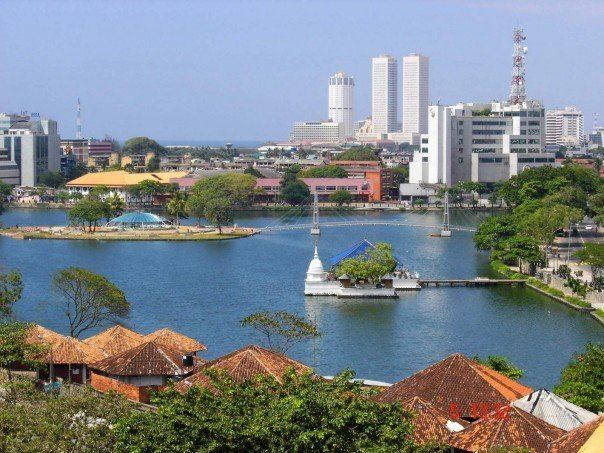
Slave Island is a suburb in Colombo, Sri Lanka, located directly south of the Fort. The suburb contains Beira Lake, a large lake and its esplanade is visited by many for recreation. Slave Island is mostly a commercial area with hotels and shopping centres.
Contents
- Colombo walks colombo 2 slave island
- Map of Slave Island Colombo Sri Lanka
- Sri lanka 17 colombo 2 18 street food in slave island
- History
- Demographic
- Infrastructure
- Military
- Diplomatic missions
- References
Map of Slave Island, Colombo, Sri Lanka
Sri lanka 17 colombo 2 18 street food in slave island
History
The name "Slave Island" was given during the period of British colonisation referring to the situation under Portuguese rule when slaves were held there, most of them black people from the Swahili coast and Portuguese East Africa. Many of these slaves later returned to Africa. However, a small group of African descendants are scattered throughout Sri Lanka and are collectively known as Sri Lankan Kaffirs.
Demographic
Slave Island is a multicultural area. The larger ethnic communities in Slave Island are the Sri Lankan Moors and Sinhalese. There are also various minorities such as Burghers, Malays and others. Religions include Buddhism, Hinduism, Islam, Christianity and various other religions and beliefs.
Infrastructure
Slave Island is served by the Slave Island Railway Station. Built with Victorian-era architectural embellishments, the station carries significant architectural and historic value. The building features stylish arches, intricate woodwork, and metal installations, which emphasize Victorian-era styles.