
Max. length 15 mi (24 km) Frozen late Nov.- late April Length 24.1 km | Basin countries United States Max. depth 528 ft (161 m) Surface elevation 59 m Outflow location Kenai River | |
 | ||
Primary inflows | ||
Frontier home living off grid on a remote island in skilak lake alaska
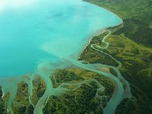
Skilak Lake is a large lake on the Kenai Peninsula, Alaska. The lake is part of the Kenai River system but also contains glacial runoff, being fed by meltwater from Skilak Glacier. The water is exceptionally clear with a mostly rocky bottom, relatively free of aquatic vegetation. It is within the Kenai National Wildlife Refuge, and can be accessed by Skilak Lake Loop Road via the Sterling Highway. Maximum depth is 528 feet (161 m), it is 15 miles (24 km) long and up to 4 miles (6.4 km) wide in places. Early Russian explorers mistakenly believed Skilak and Tustumena Lake to be a single body of water. It is a popular destination for Alaskans due to it being only about a half-hour drive from Soldotna, and approximately two hours from Anchorage. There are two campgrounds at the lake, one is a developed campground with a host, the other un-hosted and with only basic facilities. There are many well-developed and maintained trails along the lake and its access road, as well as campgrounds and public-access cabins.
Contents
- Frontier home living off grid on a remote island in skilak lake alaska
- Map of Skilak Lake Alaska USA
- Ice fishing skilak lake alaska so much fun
- References