
Elevation 1,314 m | ||
 | ||
Location Jackson County, Oregon,United States | ||
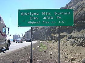
Siskiyou Summit (also Siskiyou Mtn. Summit; also referred to as Siskiyou Pass) is a summit (high point) on Interstate 5 (I-5) in the U.S. state of Oregon. It is distinct from Siskiyou Pass, which is a nearby, historical mountain pass. Siskiyou Summit is situated in the Siskiyou Mountains, approximately 4 miles (6.4 km) north of the California border. At 4,310 feet (1,310 m), it is the highest point on Interstate 5. When the highway was rebuilt on its current alignment, road cutting lowered the elevation of the summit by 49 feet (15 m).
Contents
Map of Siskiyou Summit, Oregon 97520, USA
Geography
The Siskiyou Mountains form the watershed boundary between the Klamath and Rogue Rivers and are also a rough natural separator between Oregon and California. The summit on Interstate 5 is about 25 miles (40 km) north of Yreka, California, and 0.5 miles (0.80 km) east of the historical Siskiyou Pass, the most used mountain pass in the state. The Pacific Crest National Scenic Trail crosses the highway here on the way to Mexico from Canada.
Climate
The road over Siskiyou Summit is typically closed to traffic for many days during winter due to severe weather conditions. At times, it can be closed during winter even when the weather is fine. Regardless, weather data is important to those involved in transportation over the summit. Average monthly temperatures and rainfall are given in the table below. Snow generally falls during the months of November through April, typically peaking with four such days in December. The wind speed over the course of a year varies from an average of 13 km/h (8.1 mph) in May to episodes of 80 km/h (50 mph). The average number of rainy days per month varies from 11 in December to only two in June, August and September.
History
The Hudson’s Bay Company carved a route from Oregon to California during their hunt for furs and pelts following Native American trails. HBC developed the Siskiyou Trail in 1827, which included crossing Siskiyou Summit. In the 1830s, Ewing Young, using horses and mules, led hundreds of cattle over the Siskiyou Trail, necessitating its widening; this process, which took three months to complete, linked the Shasta Valley in California with the Rogue Valley in Oregon. Scientists and cartographers of the United States Exploring Expedition carried out studies along this trail in 1841, while miners of the California Gold Rush traversed the trail to reach the gold fields. In the 1860s, the trail was widened so that stagecoaches could easily traverse it. The first telegraph line was added in 1864. Only in the 1960s did it become the modern highway now designated Interstate 5.
Road
The summit “towering 4310 ft straight up and straight down with curves thrown in for variety”, has enough space for parking two lanes of rigs on both flanks of the road. Since the gradient is about 6%, it is a preferred place for truckers to park, refuel, check the condition of their vehicles, and rest. The road down from the summit on the north side is steep and winding. During winter, reaching the summit can be a challenge due to snow and ice on the pavement. Since 2008, with the closure of the rail link, the highway has seen greater use by truckers to carry timber and finished products. In order to reduce reliance on this hazardous mountain road and to reduce the expense of highway transport, proposals are have been made to reopen the rail link.