
Impounds Dom Noi River Opened 1971 | Opening date 1971 Height 42 m (138 ft) Construction began 1968 | |
 | ||
Location Sirindhorn District, Ubon Ratchathani Province, Thailand Type of dam Earth core rockfill dam Similar Pak Mun Dam, Kaeng Saphue Public Park, Chulabhorn Dam, Wat Sirindhorn Wararam, Ubol Ratana Dam | ||
Sirindhorn dam ubon ratchatani thailand sirindhorn dam video
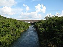
The Sirindhorn Dam is located in the northeastern province of Ubon Ratchatani, Thailand. It impounds the Lam Dom Noi River, and its reservoir is the province's largest water resource. The dam was commissioned in 1971 to serve as a hydropower facility as well as to supply irrigation water. All of the electricity generated by the dam is destined for domestic markets. The dam was constructed and is owned and operated by the Electricity Generating Authority of Thailand and is located in the Mekong River Basin, just upstream from the controversial Pak Mun Dam
Some 2,000 villagers were resettled to make way for the dam's reservoir. Many claim they did not receive adequate compensation for the loss of their livelihood and only received compensation for 80% of their land. Furthermore, they claim that the land in the resettlement village is of poor quality and few crops can be grown, and that a proposed irrigation canal was never built.
The reservoir and dam power the Sirindhorn Hydropower Plant, which has an installed capacity of 3 units of 12,000 kilowatts each and annual energy production of 90 GWh.
There is a park near the dam headquarters and a restaurant and bungalows for visitors. There is a golf course in this area also, at the north end of the lake.