
- left Bârlad Length 706 km | - elevation 1,238 m (4,062 ft) Basin area 44,835 km² Discharge 220 m³/s | |
 | ||
- average 250 m/s (8,829 cu ft/s) | ||
The Siret or Sireth (Ukrainian: Сірет or Серет, Romanian: Siret [siˈret], Hungarian: Szeret, Russian: Сирет) is a river that rises from the Carpathians in the Northern Bukovina region of Ukraine, and flows southward into Romania before it joins the Danube. It is 647 km (402 mi) long, of which 559 km (347 mi) in Romania, and its basin area is 44,811 km2 (17,302 sq mi), of which 42,890 km2 (16,560 sq mi) in Romania. Its average discharge is 250 m3/s (8,800 cu ft/s). In ancient times, it was named Hierasus (Ancient Greek Ιερασός).
Contents
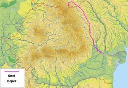
Map of Siret, Romania
Towns and villages
The following towns and villages are situated along the river Siret, from source to mouth: Berehomet, Storozhynets, Siret, Grămești, Zvoriștea, Liteni, Dolhasca, Pașcani, Stolniceni-Prăjescu, Roman, Bacău, Adjud, Mărășești, Galați.
Tributaries
The following rivers are tributaries to the river Siret:
Left: Bahna, Molnița, Bahna, Gârla Sirețel, Gârla Huțanilor, Vorona, Pleșu, Turbata, Pitrosul, Trestioara, Sirețel, Sodomeni, Stolniceni, Hărmănești, Pârâul Țigăncilor, Mihailei, Boca, Albuia, Vulpășești, Țiganca, Icușești, Glodeni, Râpaș, Pârâul Morii, Răcătău, Soci, Fulgeriș, Polocin, Lupa, Bârlad, Călmățui, Geru, Mălina, Cătușa.
Right: Malyi Seret, Găvan, Negostina, Verehia, Baranca, Leahu, Hănțești, Grigorești, Sălăgeni, Suceava, Șomuzul Mic, Șomuzul Mare, Probota, Conțeasca, Ruja, Valea Părului, Podul Turcului, Tămășeni, Moldova, Valea Neagră, Turbata, Bistrița, Cleja, Răcăciuni, Orbeni, Valea Seacă, Botohan, Fântânele, Conțești, Trotuș, Valea Boului, Carecna, Zăbrăuț, Șușița, Gârla Morilor, Putna, Leica, Râmnicul Sărat, Buzău.
2010 floodings
During July 2010, Gheorghe Flutur, president of Suceava County, told the Mediafax news agency his region was one of the worst hit in the country in the morning of the 29th as he co-ordinated local flood relief work in his stricken county. Later that day the River Siret threatened to break through the dykes protecting the town of Șendreni, as locals and emergency services reinforced the dykes with truckloads of sandbags to prevent the river breaking out and flooding the town.