
Last eruption 1877 Easiest route Scramble | First ascent 1880 Elevation 4,873 m Parent range Andes | |
 | ||
Similar Rumiñawi, Pasochoa, Antisana, Illiniza, Quilindaña | ||
Sincholagua is an inactive volcano located in Ecuador 17 km (11 mi) northeast of Cotopaxi Volcano and 45 km (28 mi) southeast of Quito. It is the 12th highest peak in the country at 4,899 m (16,073 ft) but also one of the lesser known ones. The name of the mountain comes from the indigenous language Quichua and means "strong above". Due to its close proximity to Cotopaxi, the second highest peak in Ecuador and the most popular volcano, it is far less frequently visited compared to other mountains in the country. It has a sharp peak and at one point had glacial cover year round, but all of the glaciers melted a few decades ago. However, snow can still be seen on the peak since there is there is sometimes heavy snowfall at the summit.
Contents
Map of Sincholagua, Ecuador
Climbing Sincholagua
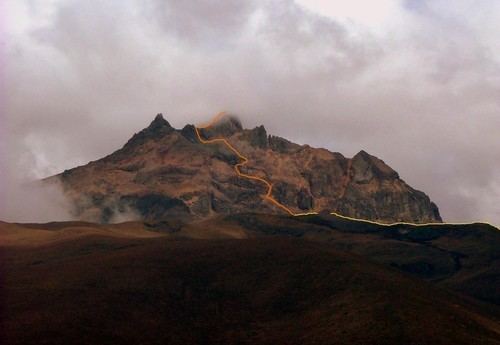
Sincholagua is one or the least frequently climbed mountains in Ecuador because it is difficult to access and less well known compared to other mountains and volcanoes in the country. There is also a long hike to access it compared to other volcanoes like Pichincha and Cotopaxi, making it more difficult to get to. Sincholagua is best known for views of the surrounding mountains such as Cotopaxi and Antisana as well as the Western Cordillera and the Amazon rainforest. The climb is of moderate difficulty and takes an estimated three hours and thirty minutes to reach the summit from base camp with ideal weather conditions. The Northwest ridge is the normal route up the mountain and was used by the first climbers. People who want to climb it usually come in from the south through Cotopaxi National Park to reach the volcano. It can also be accessed from Quito.
History
The first person to reach the summit of Sincholagua was Edward Whymper in 1880. He is best known for being the first to ascend Matterhorn mountain in Switzerland. Sincholagua lost all permanent glaciers on its peak decades ago, but before that had a glacier cover about 1.5 kilometers long. A river that runs around and on the mountain, the Río Pita, widened due to the last major eruption in 1877. When Whymper climbed Sincholagua, the Río Pita was 200 feet wide and 3 feet deep, and in 1892, after the eruption it was 1,100 feet wide and 50 feet deep at its widest and deepest. Currently it is considered a stream.