
Topo map USGS Bobs Mountain Prominence 451 m Volcanic arc Cascade Volcanoes | Elevation 1,330 m Parent range Cascade Range | |
 | ||
Similar North Gardner Mountain, Larch Mountain, Mount Fernow, Buckner Mountain, Mount Spickard | ||
Silver Star Mountain is an extinct volcano in the southwestern Cascade Mountains in the U.S. state of Washington, named for the pattern of five prominent ridges that radiate from the summit in the shape of a star. The two peaks of the mountain dominate the horizon east of Vancouver, Washington. The mountain is the focus of the Silver Star Scenic Area. In September 1902 Silver Star Mountain was the center of the Yacolt Burn, the largest fire in Washington history until 2014, which took 38 lives and burned over 238,000 acres (963 km2) The smoke was so thick that street lights glowed at noon in Seattle 160 miles (260 km) away.
Map of Silver Star Mountain, Washington 98675, USA
With the loss of vegetative ground cover, a series of rockslides occurred on the slopes of Silver Star Mountain and neighboring uplands that also were affected by the fire. The result is a landscape that has resisted natural reforestation for more than a century. Wildflowers and other species of flora that thrive above the timberline, elsewhere in Washington, are found here despite the altitude being 2,000 feet (600 m) lower than the timberline usually is in the region.
Silver Star Mountain is the center of a pluton of magma that was injected into the area 20 million years ago and cooled to solid rock under the surface, producing small deposits of gold, zinc, copper, zeolites, quartz and calcite. Small abandoned gold mines can be found in creek bottoms throughout the area. E.A. Dole, an early settler, struck silver on the mountain in 1874. He named the mine Silver Star Quartz Ledge. The ore gathered was assayed at 41.17 silver and 63.72 lead per ton.
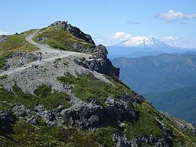
The higher north peak was once the site of a fire lookout. There is an unobstructed 360 degree view of the entire Portland, Oregon, metropolitan area, as well as views of the Columbia River Gorge, the Pacific Coast Range, Mount Saint Helens, Mount Rainier, Mount Adams, Mount Hood, and Mount Jefferson.
The area is accessed from the west by a trailhead on County Grade Road 1200 at Grouse Creek Vista, which is a pass between Silver Star Mountain and Larch Mountain. Forest Road 4109 scales the northern ridge to a trailhead 1.9 miles (3.1 km) from the summit.
The highest point in Clark County, Washington, is Sturgeon Rock, a basalt outcrop that lies on the county line just west of the Silver Star summit. For many years an error on United States Geological Survey topographical maps has misnamed a broad wooded peak lower on the ridge near the Tarbell Trail as Sturgeon Rock.