
Founded February 3, 1833 Mexican Postal Code 36100 Elevation 1,780 m Area code 472 | Time zone CST (UTC-6) Website www.silao.gob.mx Local time Tuesday 11:29 AM | |
 | ||
Weather 26°C, Wind S at 0 km/h, 18% Humidity | ||
Driving in mexico guanajuato silao
Silao (official name: Silao de la Victoria) is a city in the west-central part of the state of Guanajuato in Mexico. It is the seat of the municipio with the same name. As of the 2005 census, the city had a population of 147,123, making it the seventh-largest community in the state. Silao is a center of agricultural and industrial activity.
Contents
- Driving in mexico guanajuato silao
- Map of Silao Guanajuato Mexico
- Holiday inn express silao aeropeurto bajio silao mexico
- Airport
- Toponymy
- History
- Geography
- Geology
- Hydrography
- Climate
- Economy
- Population
- Ethnic Groups
- Religion
- Historic Monuments
- Tourist attractions
- Business district
- References
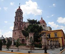
Map of Silao, Guanajuato, Mexico
Holiday inn express silao aeropeurto bajio silao mexico
Airport
This city is served by the Del Bajío International Airport. It functions as the central airport for the cities of Irapuato, Guanajuato, León, and Salamanca.
Toponymy
In its original Nahuatl, it was called Tzinacua by the Otomi and Purépecha natives. Tzinacua loosely translates into 'place of dense fog', derived from the quantity of thermal waters surrounding the area. In the Otomi language its name is Tsinäkua that also means 'place of dense fog'.
History
In the place where Silao now sits, there was an Otomí settlement that was conquered by the Purépecha tribe. It then received the name Tzinacua, that in English means "place of dense fog", because in the area of Comanjilla, there were columns of water vapor rising from thermal springs. The name evolved to 'Sinaua', 'Silagua' and finally 'Silao'.
Geography
Silao is located in the Mexican state of Guanajuato. It is situated 100° 25´ 59´´ longitude west of the Greenwich meridian and 20° 56´ 24´´ latitude north. Its altitude is 1,780 meters above sea level.
The municipality of Silao has an area of 531.41 km², equivalent to 1.76% of the total state area. The city of Guanajuato lies to the east and north of Silao; to the south lies Irapuato; to the west is Romita; to the northwest is León.
Geology
The territory of Silao is almost planar formed in by the Bajío, between its few important elevations, one can find the 'Cerro del Cubilete' whose altitude is 2,570 meters above sea level and is considered the geographic center of the country.
Hydrography
The Silao River, crosses the major part of the municipal territory. It is fed by the Magueyes, Pascuales, Hondo, and Tigre streams, as well as the Gigante River, which is its major tributary. Within the municipality are some streams of importance, like those of the Agua Zarca, San Francisco, El Paraíso, Pabileros, and Aguas Buenas.
Climate
The climate of the city is semi-arid in the majority of the territory, with rains in the summer and an average annual temperature of 28 °C. Temperatures can rise as high as 34 °C in the month of June, and a minimum of 0 °C has been reached in the months of December and January. However, in the northeastern zone the climate varies to semi-dry with a temperature predominantly in excess of 28 °C. Precipitation varies between 600 and 800 millimeters per year.
Economy
Silao is a center of agricultural and industrial activity in the area, with a wide variety of farm crops, produce and dairy packing plants and a General Motors truck and SUV assembly plant which as of 2016 makes one third of Chevrolet and GMC Full-size Pickups.
Population
According to the results presented by the second 'Conteo de Población y Vivienda' (census) of 2005, the municipality counts a total of 147,123 inhabitants.
Ethnic Groups
The indigenous population of Silao is limited to 203 inhabitants that represent 0.15% of the total municipal population. The principal native languages are Mazahua and Nahuatl.
According to the second 'Conteo de Población y Vivienda' (Census) of 2005, there are a total of 187 persons who speak some indigenous language.
The municipality has a density of 250 persons per square kilometer and an average population increase of 1.6%.
Religion
95.8% of the population of Silao (as of 2000) are Roman Catholic. Approximately 1.8% are Protestants and Evangelicals, and 1.4% are other religions. The last 1% either stated they don't have a religion or it wasn't specified.
Historic Monuments
Tourist attractions
Some of the attractions in Silao are:
Silao is also central to other cities and towns of interest to tourists. The cities of Guanajuato and Romita are approximately 25 minutes by highway. León and Irapuato are about 35 minutes by highway.
Business district
This District is located at Guanajuato Puerto Interior The business district is development at this time. This District is designed to lodge: hotels, financial and commercial buildings