
Country Philippines Barangays Area 215 km² Province Southern Leyte | Established June 20, 1950 Time zone PST (UTC+8) Local time Wednesday 1:22 AM | |
 | ||
Region Eastern Visayas (Region VIII) District Lone district of Southern Leyte Weather 25°C, Wind NW at 2 km/h, 98% Humidity | ||
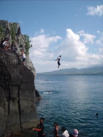
A rock like island the pelada rock in silago southern leyte philippines
Silago is a 4th class municipality in the province of Southern Leyte, Philippines. According to the 2015 census, it has a population of 12,775 people.
Contents
- A rock like island the pelada rock in silago southern leyte philippines
- Map of Silago Southern Leyte Philippines
- Earthquake drill silago southern leyte
- History
- Republic Act
- Barangays
- Natural attractions
- Education
- References
Map of Silago, Southern Leyte, Philippines
It used to be barrio of Hinunangan until Executive Order No. 326 dated May 17, 1951 separated it from the mother town. The town has an ebony beach with unique black sand.
Earthquake drill silago southern leyte
History
When the Spaniards arrived, they asked the natives the name of the place. The natives, not understanding the language of the Spaniards, failed to answer the question and instead pointed to the Tuog trees where there were so many bats hanging and said “Tuay daghang Cabug”. The Spaniards looked towards the Tuog trees and, seeing many bats, called the place Murcielago, Spanish for "bat". Over time, Murcielago was shortened to Silago.
Silago was once part of the Municipality of Hinunangan, located in the northernmost part of the said town. For several years, Silago was under the political jurisdictions of Hinunangan, even during World War I and II.
During World War II, Silago was chosen as the site of submarine landing of American military arms and equipment for the Leyte guerillas. The military hardware was efficiently moved to Leyte by hundreds of volunteer guards under the Leyte area command of Col. Ruperto K. Kangleon.
After the Second World War, Silago became more progressive and had increased its population, and thus became the biggest barangay of Hinunangan. Progress served as pushing factor that Silago has availed and gained qualifications to become a municipality.
In 1948, the Secretary of National Defense Ruperto Kangleon worked hard for the conversion of barrio Silago to a municipality. Finally on June 20, 1950, the new Municipality of Silago was inaugurated by virtue of an Executive Order No. 326 issued by President Elpidio Quirino. Such Executive Order was chartered through Republic Act No. 5962 “Creating the Municipality of Silago in the Province of Southern Leyte” on June 21, 1969.
This was made possible also through the invaluable services and voluntary effort extended by the late Canuto Capapas and Apolonio A. Lucero. These two Silagonhons even donated real properties as lands to meet the requirements of becoming a municipality.
The first set of Municipal Officials were appointed by President Elpidio Quirino on May 17, 1951. It was headed by Hon. Felix Balagon as Municipal Mayor, Hon. Leon Fortaliza as Vice Mayor, Hon. Manuel Tomol, Hon. Enrique Sarona, Hon. Modesto Miras and Hon. Manuel Cruzada as councilors.Mr. Pedro Tomol was appointed as Municipal Secretary.
Republic Act
REPUBLIC ACT NO. 5962 - An Act Creating the Municipality of Silago in the Province of Southern Leyte
Barangays
Silago is politically subdivided into 15 barangays.
Natural attractions
Silago got her name from the word “murcielago” which is a Spanish term for bat, because of this species' dominance in the locality. Proof to this is the giant bat sanctuary at Barangay Catmon. Along the coastal barangays of the town, there are clean beaches and a structure designed by nature lying in the town’s deep blue sea known as Pelada Rock, also locally known as “Batong Dako" meaning large rock, which was occupied and utilized as a camp by the Japanese Imperial Army during the Second World War. The peculiar beauty of this rock is enhanced with the abundance of birds hovering and built their nest on it, sea snakes making the rock as their dwelling place, with fish and other marine products surrounding it. The rock is located just a short distance from the shore of Barangay Laguma and Barangay Salvacion.
Farther north, is a natural rock formation with a length of more or less 50 meters from the shore and about 10 meters wide.
The interior of Silago is mountainous, in which is the town’s vast forest, home of the wild pigs locally known as “Baboy Ihas”. Among all the municipalities of the province, Silago is identified to have the biggest forest area.
The municipal tree park is another kind of tourist attraction in the municipality where fresh breeze and songs of the birds make the atmosphere pleasantly unique. On its northern part is a clean and clear river suitable for swimming.
In the upper portion of the town, at different locations, are waterfalls. Kagut-an falls is more or less 1 kilometer away from the national highway, at Barangay Katipunan. This falls is paired with another falls near its vicinity, locally called as Kagut-an Dako Dos Falls, which possesses an exceptional attraction to all who sees it. In the same barangay is another falls called Kagut-an Gamay falls. In Barangay Mercedes, about 1 kilometer distance from Mercedes Barangay Road, is Sitio Kawayan Falls with a height of about 10 meters.
Another falls is in Barangay Tubod distinctive in structure with matching cave on its opposite side. Water from this falls, along its way meets the Lanang River flow, which also has its own unique attraction.
Aside from Lanang River, which is located at the town’s mountain barangay, is the Maag River that crosses along the national highway in Poblacion District 1. This river forms a lake that is suited for boating recreation. At the mouth of the river is the brown fine sand beach of Silago, which is more or less 1 kilometer long.
In the months of November to February, Silago's beaches are ideal for surfing with huge sea waves, comparable to waves in Siargao.
Education
Elementary schools:
Almost all barangays has Elementary / Primary Schools, few are mentioned below:
High schools: