
Parent range Isolated range Elevation 1,209 m | Province Province of Albacete | |
 | ||
Location Valle de Cofrentes, Valencian CommunityAlmansa, Castile-La Mancha Similar Sierra de Enguera, Cueva de la Vieja, Sierra de Orihuela, Sierra de Callosa, Castle of Almansa | ||
Sierra del mugr n castellar de meca y rinc n de san pascual
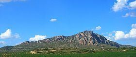
Sierra del Mugrón is a 16.6 km (10 mi) long mountain range located between the Valle de Cofrentes (Valencian: Vall de Cofrents) comarca, Valencian Community, and Almansa, Castile-La Mancha, Spain. It is an isolated range between the Iberian System and the Cordillera Prebética. Its highest point is 1,209 m. The northern section of this range is within the Ayora (Valencian: Aiora) municipal term, while the southern belongs to Almansa.
Contents
- Sierra del mugr n castellar de meca y rinc n de san pascual
- Map of Sierra del MugrC3B3n 02640 Albacete Spain
- References
Map of Sierra del Mugr%C3%B3n, 02640, Albacete, Spain
There are remains of an Ancient Iberian settlement in Castellar de Meca, between Ayora and Alpera.
This mountain range is a quiet lonely and isolated area with a sizeable amount of wildlife, foremost of which are the wildcat, boar, little bustard, Eurasian stone-curlew, peregrine falcon, European nightjar, black wheatear, common wood pigeon, Dartford warbler, red-legged partridge and Bonelli's eagle.