
Peak Cerro del Castaño Width 15 km (9.3 mi) NE/SW Elevation 962 m | Length 58 km (36 mi) NW/SE Period Paleozoic | |
 | ||
Parque natural sierra de aracena y picos de aroche
Sierra de Aracena is the westernmost mountain range of the Sierra Morena, Andalusia, Spain. It is located in the northern part of Huelva Province.
Contents
- Parque natural sierra de aracena y picos de aroche
- Pueblos y aldeas de la sierra de aracena y picos de aroche huelva
- Description
- Protected areas
- References
The range is named after the town of Aracena.
Pueblos y aldeas de la sierra de aracena y picos de aroche huelva
Description
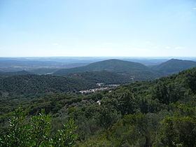
The Sierra de Aracena is not very high and its mountains have a gentle, rounded shape. The height of most of the summits lies between 400 and 900 m (1,300 and 3,000 ft). Its highest point is 962 m (3,156 ft) high Cerro del Castaño. Other notable summits are Cerro de San Cristóbal 917 m (3,009 ft) and Cerro de Santa Bárbara 814 m (2,671 ft), the latter located close to Cortegana. The Odiel and Murtigas are the main rivers in the area of the range.
The climate is relatively humid for Andalusian standards and there is a small village in most of the valleys. The undisturbed slopes of the mountains are mostly covered in forest, which is made up of Chestnut, Holm Oak and Cork Oak trees.
Protected areas
The Sierra de Aracena and Picos de Aroche Natural Park is located in the area of the range.