
Elevation 3,250 m | State/Province Oaxaca Area 1,700 km² | |
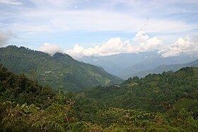 | ||
The Sierra Juárez is a range of mountains in Oaxaca state, Mexico between latitudes 17°20'-17°50'N and longitudes 96°15'-97°00'W, with an area of about 1,700 km². It is part of the Sierra Madre de Oaxaca. The range is separated from the Sierra de Zongólica to the north by the Santo Domingo River, flowing through the Tecomavaca Canyon. It stretches south-eastward to the Cajones River and the Sierra de Villa Alta. The mountains are in the district of Ixtlán de Juárez in the Sierra Norte de Oaxaca region. The range is named after Mexico's only indigenous president, Benito Juárez, who was born here in 1806 in the small village of San Pablo Guelatao. The heavily wooded area is about 62 km from the city of Oaxaca on Federal highway 175, heading towards Tuxtepec.
Contents
- Map of Sierra JuC3A1rez Oaxaca Mexico
- Terrain and climate
- Vegetation
- People
- Environmental concerns
- References
Map of Sierra Ju%C3%A1rez, Oaxaca, Mexico
Terrain and climate
The mountains climb from 500m to 3,250m, with many large and deep ravines. They are formed of folded sedimentary rocks with series of younger granitic intrusions that date from the Palaeozoic to Cenozoic, with the majority being Mesozoic. The climate is subtropical in the lower regions and temperate and subhumid above 1000m, with average temperature from 16°-20 °C. There is regular frost in the higher mountains. Annual rainfall, fed by the trade winds from the Caribbean sea, ranges from 700mm to 4000mm or more. The Valle Nacional River originates in the Sierra de Juárez, one of the major tributaries of the Papaloapan River.
Vegetation
The Sierra de Juárez is one of Oaxaca State's wettest areas and richest in forest diversity, with perhaps 2000 of the 8000 or more plant species that are found in the state. It is mostly covered by montane cloud forest, but includes tropical evergreen forests and forests of pine, pine-oak and oak. The cloud forest forms a band from 1,000-1,400 meters in height up to 2,250 meters along the northern and eastern slopes. The climate is cool (14°-20 °C) and has mean annual rainfall that exceeds 2,000mm and is sometimes much higher. The dominant trees are 20–30 m tall and include evergreen and deciduous species, palms, tree ferns, heather shrubs, vines, and moisture-loving herbs.
The tropical evergreen forest is dominated by evergreen trees 30-40m tall, with abundant lianas and tropical epiphytes. Pine and pine-oak forests, at a height from 1600-2800m have evergreen trees 25-40m tall, with grasses dominating the lower stratum. Oak forests at a height from 2000-2500m grow in areas with relatively lower rainfall that have a dry season in summer. The oak forests are found in the western, inland part of the sierra to the Rio Grande Basin.
People
The Sierra Juárez is the land of the Sierra Zapotecs, of whom President Benito Juárez was one of the most famous. The Zapotecs of the Sierra Norte, who call themselves the bene xon, are one of three major Zapotec regions in southern Mexico. The other three reside in the Isthmus of Tehuantepec, the Valles Centrales region and the Sierra Madre Oriental. The bene xon divide into four sub-cultures: Cajonos, El Rincón, Ixtlán and Choapan. Other indigenous people include the Chinantec, Mixe and Mixtec.
Environmental concerns
The sierra is home to threatened mammals such as jaguar, ocelot and brocket deer. It is also a habitat for the threatened dwarf jay (Cyanloyca nana), and is the richest region in Mexico for butterflies. It is under stress from logging, agriculture, grazing and colonization, and is potentially threatened by hydroelectric dams. There is no official plan to establish nature reserves. However, the region promotes ecotourism to help preserve the biosphere with various enterprises offering cabins, camping, access and guides for hiking and mountain-biking trails, horseback riding, bird-watching, and cave exploration.