
River mouth Rhine Length 153 km Basin area 2,832 km² Mouth Rhine Cities Bonn, Siegen, Siegburg | Basin size 2,832 km (1,093 sq mi) Discharge 52 m³/s Source Rothaar Mountains Country Germany | |
 | ||
Main source Siegerland603 m (1,978 ft) | ||
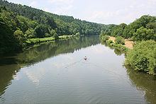
The Sieg is a river in North Rhine-Westphalia and Rhineland-Palatinate, Germany named after the Sigambrer. It is a right tributary of the Rhine and 153 kilometres in length.
Contents
Map of Sieg, Germany
The source is located in the Rothaargebirge mountains. From here the river runs southwestwards to the city of Siegen and the hills of Siegerland, both named after the river. Further west the Sieg valley forms the boundary of the Bergisches Land (northern) and Westerwald (southern). The river finally runs through a protected area east of the city of Bonn.
After passing the cities of Hennef and Siegburg it joins the Rhine near Niederkassel/Mondorf just a few kilometres north of the centre of Bonn.
Sieg Spring
The Sieg Spring (German: Siegquelle) is the source of the 155,2 kilometers long river Sieg in a high of 603 meters, near the village Großenbach, in North-Rhine-Westphalia, Germany. In 2013 the Sieg Spring has been land restored.