
Country India District Kadapa Time zone IST (UTC+5:30) Local time Tuesday 8:14 AM | State Andhra Pradesh Talukas Sidhout PIN 516237 | |
 | ||
Weather 30°C, Wind SE at 5 km/h, 69% Humidity | ||
Sidhout or Siddhavattam is a village in Kadapa district of the Indian state of Andhra Pradesh. It is located in Sidhout mandal of Rajampeta revenue division.
Contents
Map of Sidhout, Andhra Pradesh
This village was under the rule of Great Pemmasani Nayaks.
Geography
Siddhavattam is located at 14.4667°N 78.9667°E / 14.4667; 78.9667. It has an average elevation of 107 meters (354 feet). It is located beside the bank of river Penna
History
In the past, people called "Siddhas" were living in this area. They used to live under trees called "vata" (Indian Banyan tree) which were plenty in this area at that time. Hence the name "Sidhas" + "Vata" = Sidhavata, or simply Sidhout. Sidhout lies in the banks of river Penna in the route of Kadapa - Badvel via Bhakarapet. It is 20 km away from Kadapa.
From 1807 to 1812 Sidhout was the district headquarters. But since it is on the bank of river Penna, every time the river floods, the place was used to get isolated. Hence the district headquarters were shifted to Kadapa.
The fort built here attracts tourists very much. This popular fort was taken under control by Archeology Department of India in 1956. Not only fort, but this place is also famous for many temples and mosques. Among these Ranganadha Swamy temple is very popular. The 16 pillar Mantapam build on the name of Baakara Panthulu in the local burial place is also very popular.
This place is best to visit in the months of September and October.
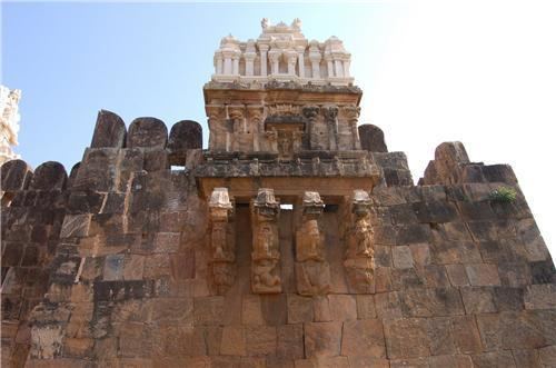
Sidhout Fort
Sidhout Fort, constructed in 1303 AD, lies on the banks of the Pennar River. The fort extends over an area of 30 acres (12 ha). Visitors can view gateways and decorated pillars at the two ends of the fort. Top of the fort has been adorned with carvings of Gajalakshmi. Moreover, the 17 square bastions which once used to protect the region are still visible in the fort.
The fort houses an ancillary passage which allows the visitors to gain access even after the closure of the main gates. It is considered as the gateway to Dakshina Kashi. The temples present inside its premise include the Ranganayaka Swamy Temple, Siddheswara Temple, Durga Temple and the Bala Brahma Temple.
The fort here was much developed under the rule of king Varadha Raju, who is the son-in-law of Sri Krishna Deva Raya. This fort was just a mud fort at the time the area was ruled by "Matli Rajulu". Later it came under the control of Varadha Raju.
Earlier it was a part of Udayagiri Kingdom. Matli Yellama Raju used to support the second Venkatapathi Rayalu in many wars. For this favour, Sidhout was given to Matli Yellama Raju as a gift along with some other places. Later Matli Anantha Raju remodelled the fort as Rock Fort.
Later Aurangajeb's commander Mr Jumla II captured Sidhout. Later Aarkatu Nawabs occupied Sidhout. In 1714 Abdul Nabi Khan, who was ruling Kadapa conquered Sidhout. This place was also ruled by Mayana Nawabs for some period. At last in 1799, Sidhout went into the hands of British East India Company.
Panchayats
The following is the list of village panchayats in Sidhout mandal.